Col Openings

davidof
Posts: 3,127
Some information:-
Col du Glandon on the N. side is snowfree to 1600m, on the South side you can cycle as far as the Col but the road is not officially open so there could be a lot of debris (stones etc) and your medical insurance may not be valid if you crash. The Noyer (used in last year's Criterium du Dauphiné) opened on the 30th April. Le Gioberney on the 27th.
The col d'Agnel is scheduled on the 6th June and the Galibier 28th May with the Izoard just after.
If you have additional info post it below.
BASI Nordic Ski Instructor
Instagramme
Instagramme
0
Comments
-
There is a fairly extensive list of Cols here:
http://www.cols-cyclisme.com/ouverture-cols.htm
The snow line in the Northern Alps at present appears to be around 1600m (lower on north-facing slopes). There has been some fresh snow at that altitude and above in the past week. The weather is forecast to improve this week.0 -
cc78 wrote:
I was more interested in when cols are scheduled to be opened this year and what the actual state is on the ground. For example, in your link the Col du Coq is listed as closed but it is officially open and has been for some time. As you are in la Giettaz you might know what the actual situation is around you.BASI Nordic Ski Instructor
Instagramme0 -
Around here the Colombiere and Cormet de Roselend are still closed, but everything else is open, as far as I am aware.
Difficult to find opening dates although my general feeling is most cannot be too far away.
Croix de Fer is open as I know someone who cycled up it yesterday.0 -
Thanks for the info, Quite an early opening for the Croix de Fer. The Glandon is open as far as the football pitch but normally needs avalanche control work to open the last section. Iseran open on the south side as far as the St Charles bridge.
I may cycle the Croix de Fer this week if the weather clears.BASI Nordic Ski Instructor
Instagramme0 -
Not long now until this starts again - http://1jour1col.com/0
-
Article in today's Dauphiné says work is underway, but no fixed dates yet:
http://www.ledauphine.com/savoie/2014/0 ... tiers-oyel0 -
The Col de la Colombière is now open.0
-
Thanks for the heads up.
Yesterday I I cycled up the Croix de Fer but started with a warmup on the picturesque Lacets de Montvernier: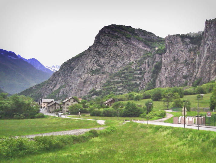
It is a 300 meter climb on a series of switchbacks with views down the Maurienne valley
up on the plateau you get views over the still snow capped mountains, here the Aiguilles d'Arves
then back down into the valley and across to the start of the Croix de Fer, a 30km / 5% climb but that stat hides the fact that there are two sections of downhill on the route, both the start km and the final section from St Jean are steepish climbs.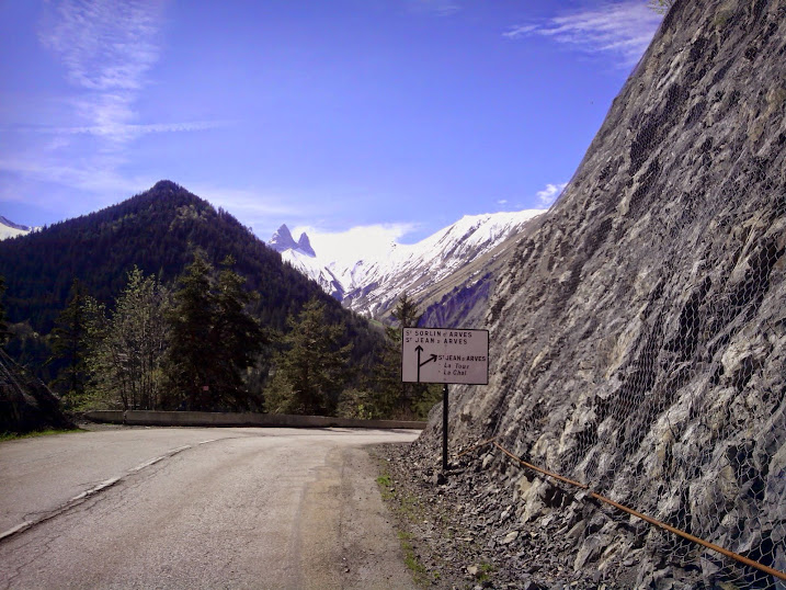
Temperatures needed a long sleeved jersey and some people were climbing with leggings. On the climb up I didn't see a soul except for a police motorcycle patrol. The fountain in St Sorlin was turned off so no water, I had to climb down to a stream to get stocks.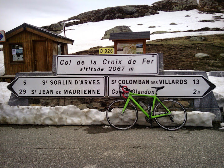
A few skiers at the Col who'd been up to the Etendart that morning plus a coterie of Dutch and Canadian cycles who had ridden the much more popular Bourg side of the climb.
Over to the Glandon which is still closed (officially) until to the 15th May where there were more Dutch.
With a bit of care plus a couple of sections of Avalanche debris to cross the Glandon was passable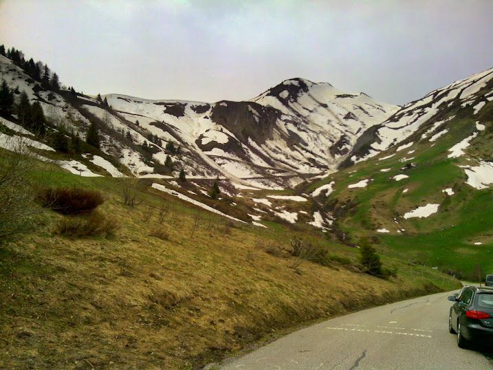
Coming back to St Jean de Maurienne there was a wedding at the little chapel you see from the autoroute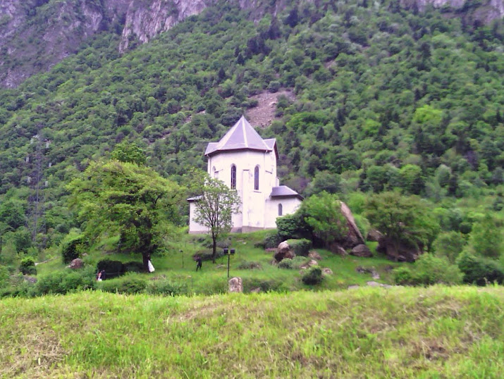 BASI Nordic Ski Instructor
Instagramme0 -
Great pictures.
Inner Ring did a piece about Montvernier earlier in the year, looks a nice little climb...
http://inrng.com/2014/01/roads-to-ride- ... ntvernier/
Do you know if the Madeleine is clear (even if not officially open)?0 -
cc78 wrote:Great pictures.
Inner Ring did a piece about Montvernier earlier in the year, looks a nice little climb...
http://inrng.com/2014/01/roads-to-ride- ... ntvernier/
Do you know if the Madeleine is clear (even if not officially open)?
That's an interesting article by Inner Ring, it is a short but esthetic climb. For the Madeleine I would imagine that the road on the south side is clear to the col or there abouts, the snow line on S faces is 2200m. The north side must still have snow though but the slopes are not as steep as those below the Gladon. You would have thought that after opening the Croix de Fer the Madeleine would have been the next priority but it always seems to open late.BASI Nordic Ski Instructor
Instagramme0 -
davidof wrote:That's an interesting article by Inner Ring, it is a short but esthetic climb. For the Madeleine I would imagine that the road on the south side is clear to the col or there abouts, the snow line on S faces is 2200m. The north side must still have snow though but the slopes are not as steep as those below the Gladon. You would have thought that after opening the Croix de Fer the Madeleine would have been the next priority but it always seems to open late.
Thanks for that. I may take a ride up there at some point in the next couple of weeks. I'll keep an eye out for the Cormet de Roselend opening too...0 -
The Inner Ring writes of the Montvenier climb, “I can’t find a trace of a major race using the road”. Not a major race, but the L'Arvan-Villards cyclosportive includes the ascent in its route (then descends to St. Jean-d-Maurienne via Hermillon). Start and finish is at St. Sorlin d’Arves.davidof wrote:
That's an interesting article by Inner Ring, it is a short but esthetic climb.cc78 wrote:Inner Ring did a piece about Montvernier earlier in the year, looks a nice little climb...
http://inrng.com/2014/01/roads-to-ride- ... ntvernier/
After the hamlet of Montvernier, you can carry on ascending to the Col de Chaussy. This ascent has on average the same slope as Montvernier, but without the extremes (the Montvenier has nearly 19% at one point, the Chaussy steepest section is about 14%), however, overall it’s harder as longer (10 km). Before Montpascal, there is a stretch of road cut into a rockface, like the Montvernier climb has. See picture.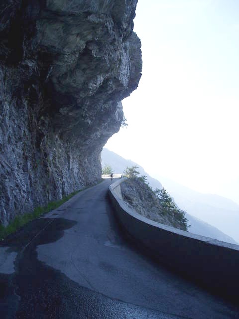
After the Col, you can descend through Bonvillard to join the lower part of the Madeleine (you come out above the 8-9 serpentines just after St. Martin), or you can head north from Bonvillard past the lake Lac du Loup and eventually join the Madeleine about 1.5 km above St. Francois-Longchamp.
Unless it’s changed, though, about 1 km after the lake, the road becomes unpaved, which means about 6 km of unpaved track to reach the Madeleine road (at the beginning it’s a bit coarse but later becomes finer; I used 25 mm tyres when I rode it).
If you want another (paved, quiet) alternate route up the Madeleine, from La Chambre you can go up the west side of the valley through Montgallafrey – you come out at the top end of St. Francois-Longchamp. Parts of it were also along a cliff-face, including through a short unlit U-bend tunnel (where you had to be careful) but I think the local authorities have recently cut back the rockface over the stretch there, including eliminating the tunnel.0 -
A couple of updates
Cormet de Roselund is now open
The Petit St Bernard will open on the 26th
The Glandon still isn't officially open but is passable by bike.BASI Nordic Ski Instructor
Instagramme0 -
Galibier will open on the 28th May (it used to open mid-May with a huge clearance operation but in times of austerity). Still a big operation at the moment with snow blowers. I don't know if the col will open on the 28th or just the tunnel, where bikes are not allowed (anyone cycled the tunnel?).BASI Nordic Ski Instructor
Instagramme0 -
The Madeleine opened this week, but sad news today... a section of snow beside the road gave way as a small group were walking on it, and they fell into the stream below. One woman has died and 2 others are in hospital. Not pleasant.0
-
some great shots of the snow clearing on the Galibier:
http://www.ledauphine.com/hautes-alpes/ ... -en-images0 -
Tourmalet still closed, came over yesterday in motorhome (sign at bottom, Aspin side, said open), barrier across at top, quite a bit of road washed away at top. Saw a car come up so another guy in a VW camper decided to go for it and I thought what the hell :shock:
Had a hairy moment where I had to squeeze through a small gap between big snowdrift and precarious overhang... but made it alive. Bit foolish I suppose but it sure got the heart pumping.
Will be fine on bike, hope to have a go later in week if weather improves a bit.0 -
I thought it might be helpful to restart this thread for anyone visiting the (northern) Alps in the near future...
Croix de Fer opened a couple of days ago.
Colombiere is scheduled to open this afternoon.
Joux-Plane, Cormet de Roselend, Madeleine, Petit St-Bernard, Glandon, Galibier and Iseran are all still officially closed.
The D1091 between Bourg d'Oisans and Col du Lautaret is closed for safety work on the tunnel at Chambon. Scheduled re-opening is June 15th. As far as I know there is no easy local diversion although maybe someone with better knowledge of that area could confirm this?
The D1212 between Ugine and Flumet is closed after around 400m of road was washed away when the river Arly burst its banks last weekend. There is no re-opening date yet but it is likely to be closed for several months, at least. There is a reasonably quick diversion in place via the D109 and the small village of Hery. A number of smaller roads in the area were also affected by landslides but most if not all of these have now been cleared.
I'll update the Col openings as and when they are confirmed, maybe someone could do the same for the southern Alps and Pyrenees?0 -
I was going to cycle the Croix de Fer yesterday but was a bit tired and its a long ride from home. May try Sunday but would drive over to St J. de M.
Glandon was being avalanche controlled on Monday and should be open in a few days. Noyer, Chat and Epine are supposed to be open, there was no snow on the Epine last week but it was still closed but passable by bike.
No idea why they haven't opened the Galibier given the Grenoble / Briancon is closed.BASI Nordic Ski Instructor
Instagramme0 -
Glandon is closed (barrier / signs) but is okay on a bike - snow covering half the road; according to someone who cycled it today.BASI Nordic Ski Instructor
Instagramme0 -
Here is a photo of the Glandon from the 7th

The Izoard is open now.BASI Nordic Ski Instructor
Instagramme0 -
Alpine cols are opening thick and fast. Izoard on Thursday (it is pretty much unreachable for us due to the Grenoble -> Briancon road closure so academic). Col du Mont Cenis. The Petit Saint-Bernard and Madeleine will open in the coming days.
Today we did the Croix de Fer loop
Col du Mollard (fantastic shady wooded climb of around 1100 meters) with the destination Croix de Fer in view behind. The big snowy peak is the Etendard.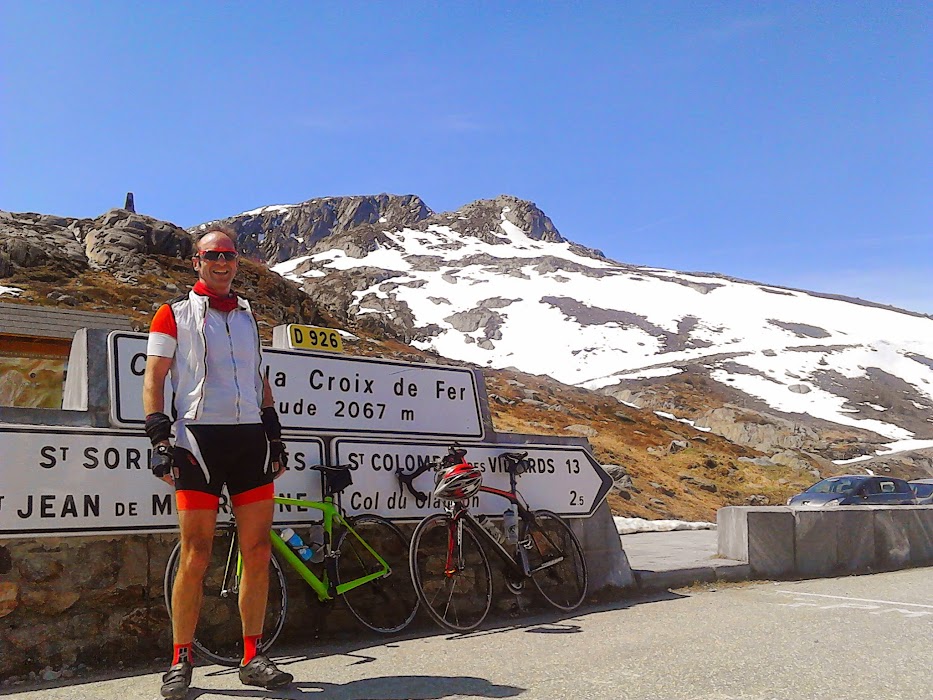
Job done, Croix de Fer. Mike had a bit of a crisis on the ueber steep road through St Sorlin, 3km at 9 to 11% but recovered strongly on the last 3km to the summit.
and the Glandon, not officially open but passable by bikes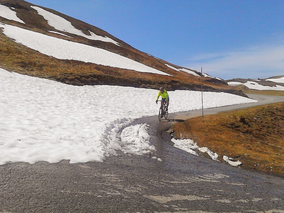
and you might think cars but this driver had a bit of an accident lower down trying to cross a mudslide still blocking the road and cracked his sump dumping 5 liters of oil into the environment.BASI Nordic Ski Instructor
Instagramme0 -
thanks for the updates, looks like a great day!0
-
The Cormet de Roselend is now open.
Galibier should follow today or tomorrow.0 -
It opened this morning as far as the tunnel (officially it opens tomorrow). The col should open next week.BASI Nordic Ski Instructor
Instagramme0 -
Col de Joux Plane will probably be closed most of the summer on the Morzine side due to a landslide before the col de Ranfolly. Not sure if it is passable on bike but the cycling events that use the col are being rerouted.BASI Nordic Ski Instructor
Instagramme0 -
Col de Joux Plane will probably be closed most of the summer on the Morzine side due to a landslide before the col de Ranfolly. Not sure if it is passable on bike but the cycling events that use the col are being rerouted.
I'm in Samoens now, the Joux Plane is passable by bike all the way into Morzine, but take care right near the top by Ranfolly. You have to go onto the grass for a few feet to get around the closure gates. After that, a few hundred yards later you can see the first of two large holes in the road where it's given way.
Just be sensible...
The upside is that there's no motorised traffic on the Morzine side, and less than usual on the Samoens side, since it's no longer a way to get to Morzine. The cafe at the top is still superb, but quieter than usual.0 -
-
Don't expect the D1091 to reopen this year. The hillside through which the tunnel goes is sliding into the lake.The D1091 between Bourg d'Oisans and Col du Lautaret is closed for safety work on the tunnel at Chambon. Scheduled re-opening is June 15th. As far as I know there is no easy local diversion although maybe someone with better knowledge of that area could confirm this?
see here for current news
There is a possible bike route on the south side of the lake - jeep track along the lakeside, footpath when it gets to Cuculet. Access may be banned if the authorities get worried about the risk of being washed away if the hillside lets go.
http://geoportail.fr/url/7FcmSy0