How do you define 'Hilly'?

GavH
Posts: 933
Probably a stupid question and one I'm quite certain has been discussed on here before but I'll be damned if I can find it.
How do you differentiate between a hilly ride and a flat ride? I know that for most (if not all!) it'll be based on the amount of height gained during a ride. At present, a 40 mile ride which gains over 2000ft in height is what I'd call 'Hilly'. Question is, am I kidding myself on and do I need to gain even more than that in the same time to qualify it as a hilly ride? I vaguely remember someone on here saying that 500ft gained for every 10 miles ridden was what they called hilly. Is that a fair rule of thumb?
How do you quantify a hill ride?
0
Comments
-
For me, 1000feet per 10 miles is hilly. When you look at some of the hillier 'brutal' sportives, they can be >10,000feet over a 100 miles.0
-
It varies, I think 111 miles with 9000ft ascent is hilly, 175 miles with 10,000ft ascent is mixed, 68 miles with 4500ft of ascent is very hilly too.0
-
1000ft per 10 miles sounds about right to me.
But depending on what you use to determine your ascent figures you can get wildly different results.More problems but still living....0 -
amaferanga wrote:100ft per 10 miles sounds about right to me.
But depending on what you use to determine your ascent figures you can get wildly different results.
Wut? That's like 1000ft in 100 miles, if I cycled out into the flats going out Lincolnshire way I'd probably still accumulate that from all the various bridges going over motorways and lumps and bumps that you get everywhere.0 -
This may sound daft, but a ride with hills in is hilly for me. (As in known climbs)...0
-
freehub wrote:amaferanga wrote:100ft per 10 miles sounds about right to me.
But depending on what you use to determine your ascent figures you can get wildly different results.
Wut? That's like 1000ft in 100 miles, if I cycled out into the flats going out Lincolnshire way I'd probably still accumulate that from all the various bridges going over motorways and lumps and bumps that you get everywhere.
Meant 1000ft. Thought that'd be fairly obvious.
I've now edited my post.More problems but still living....0 -
So what is 500ft per 10 miles? Flat? That's still hilly O_o
When I go int peaks it must be hilly, I try go up the hardest climbs, following the hardest line. None if this zig zaging lark.0 -
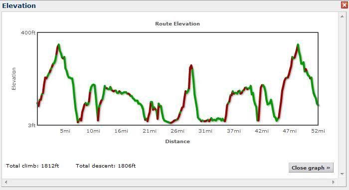
Attaching climbing numbers to miles is an obscure way of defining a route:
The below image is a total of 2,631ft of climbing over 52 miles, and includes Leith Hill (100ft off the top) - the highest point in Surrey, and second highest point in the South-East of England. The actual ascending parts though are only over 10.48 miles.
Surely the best way to determine a hilly route is -as Nap D says - one which involves hills. Failing that, simply profile the terrain? 0
0 -
A route that involves lots of long pointy bits?0
-
Does it matter? Hard and easy are a better definition for me. If you feel you can do more hills then do them and see how it goes. As long as you enjoy it.
 0
0 -
I think it does matter if you are planning routes and need reasonable estimates of ETA etc.
FWIW, and I am relatively old and inexperienced (second season only), for me Richmond Park sets a standard - stop sniggering oop there! 11k run 110 m ascent (1% average gradient) in two bites; it is lumpy rather than hilly. Routes less than 0.75% and greater than 1.25% average gradients are, for me, flat or hilly respectively. As for v hilly I would rather not go there for the moment.
From here to Brighton including Turners Hill and the Beacon almost meets this average gradient test for being hilly - about 87k and 1050 m ascent; however, I would regard any day requiring more than 1000m ascent as hilly regardless of average gradient. A jaunt in the Surrey Hills (typically 50 m and 800m vertical gain) certainly meets my test.
This may not help you but at least I have clarified my own thinking!
Enjoy the challenge.vintage newbie, spinning away0 -
Furrag wrote:Attaching climbing numbers to miles is an obscure way of defining a route:
The below image is a total of 2,631ft of climbing over 52 miles, and includes Leith Hill (100ft off the top) - the highest point in Surrey, and second highest point in the South-East of England. The actual ascending parts though are only over 10.48 miles.
Surely the best way to determine a hilly route is -as Nap D says - one which involves hills. Failing that, simply profile the terrain?
@furrag - care to share the route") 0
0 -
I agree with the 1000 ft in 10 miles. Etap du Dales was about that, whereas did the York 100 today which was 106 miles and 4500 feet and I considered that fairly flat with only one major climb.
Depends where you live I guess. Even my basic 16 mile morning loop is 1200 ft but I don't consider it hilly - even the damn 10 mile TT course is about 250ft0 -
http://connect.garmin.com/activity/43260851wvanry wrote:@furrag - care to share the route0 -
Todays ride, i wouldn't say that that was hilly, i'd say it's reasonably flat, but from about 20mi in, there was a headwind all the way home.
As for hilly rides, i hope to do this next week.. That is hilly!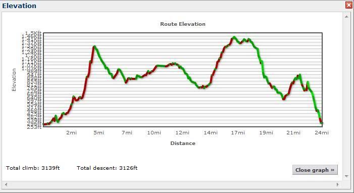 0
0 -
It was indeed discussed before because I asked it:
http://www.bikeradar.com/forum/viewtopic.php?t=126886400 -
anto164 wrote:
Todays ride, i wouldn't say that that was hilly, i'd say it's reasonably flat, but from about 20mi in, there was a headwind all the way home.
As for hilly rides, i hope to do this next week.. That is hilly!
See I'd class the 1st image to be the hilliest, and the second image to be of the route that is the easiest despite the higher elevation gain.
I'm confused as to how the York 100 is flat, it's going over the wolds and does indeed only have 1 major climb, but it's so up and down it's not flat, a flat ride would not be over rolling terrain that would be a mixed ride.0 -
If you need to get into the little ring at any point?"A cyclist has nothing to lose but his chain"
PTP Runner Up 20150 -
doyler78 wrote:It was indeed discussed before because I asked it:
http://www.bikeradar.com/forum/viewtopic.php?t=12688640
Gents thanks for the responses - very insighful as to how others classify a hilly route. Doyler, thanks, but I was thinking someone had asked this a lot further back. Nevertheless, ironic that I was asking the question just prior to heading into the heart of Down for what I thought would be a 'hilly' ride. I ended up doing just 38miles with just over 1900ft of ascent and it certainly felt hillier than my usual rides these last 2 weeks. The Ardtanagh Rd was a bit of a shock! :shock:0 -
ShockedSoShocked wrote:If you need to get into the little ring at any point?
I can do some proper hilly routes in 50/23, does not mean they are not hilly, it just means I'll be abit slower than everyone else and get back with VERY painful knees.0 -
GavH wrote:doyler78 wrote:It was indeed discussed before because I asked it:
http://www.bikeradar.com/forum/viewtopic.php?t=12688640
Gents thanks for the responses - very insighful as to how others classify a hilly route. Doyler, thanks, but I was thinking someone had asked this a lot further back. Nevertheless, ironic that I was asking the question just prior to heading into the heart of Down for what I thought would be a 'hilly' ride. I ended up doing just 38miles with just over 1900ft of ascent and it certainly felt hillier than my usual rides these last 2 weeks. The Ardtanagh Rd was a bit of a shock! :shock: Yeah - mid and south down a real mix of rolling and hilly. It's fairly easy to rack up big ascents in short rides even though we don't have any big/big mountains. If you look at the Dromara CC Hilly 125km route you get an idea of the major climbs up round Slieve Croob and then on out to the Mournes. I done the Dromara Hilly 125km a week ago. I came home with over 8,000ft in 93 miles. That was fun 0 -
freehub wrote:
I'm confused as to how the York 100 is flat, it's going over the wolds and does indeed only have 1 major climb, but it's so up and down it's not flat, a flat ride would not be over rolling terrain that would be a mixed ride.
Well, the question was how do 'you' define hilly - as in a personal definition. Compared to the other sportives I've done, Etap du Dales, Lakeland Loop, Colomba Chemo classic etc, the York 100 was relatively flat. There were stretches of 10 and 20 miles at a time with no hills. York in general is considered very flat, hence why there are so many bikes parked up there.
I think the only answer is that its personal to where you live. If you live in Norfolk you'd consider the York 100 very hilly, but compared to the Dales, where I do my daily rides, it wasn't.0 -
Hilly is when I look up and focus on the top of the climb (if you can see it) and let out a sigh.. 0
-
I was in your neck of the woods a couple of weeks ago, Lisburn to Slieve Croob & back is definitely what I would call hilly by any definition!GavH wrote:into the heart of Down for what I thought would be a 'hilly' ride.
More generally, I have always been a bit suspicious of total ascent figures, both from GPS and mapping software/websites: I've often seen them give quite distinctly different figures for the same route. Does anyone know of any info on the accuracy or otherwise of the different methods?0 -
Hilly or flat is fairly easy but it's where rolling fits in that I have a problem with. I think a lot depends on where you ride as well, a fairly flat or rolling ride in my neck of the woods, the Peaks or North Yorks Moors might be classed as hilly but someone who usually rides in the Fens.0
-
If you have to ask if it is a hill then it is not. Same goes for hilly rides.0

