Satnav (e.g. Garmin 800 / Bryton 50E) - what can they do?

alsion
Posts: 2
I would like to get a bike "satnav". Currently I use OS maps or books, but it is annoying to stop all the time to get the map/book out my bag, especially in wind and rain. I recently got a handlebar map holder (primarily for orienteering events) and it may be that this is sufficient, but it's a bit bulky/rattly/catches the wind.
I've read lots of reviews and seems the Garmin 800 and Bryton 50E are broadly comparable. However, I am confused about the capabilities of these units in general, and whether they would do everything I want them too!
- On the hoof routing - is it possible, and practical (given the small screen and controls) to plot a ride while you're out? Or - realistically - do you always need to do this on a computer at home?
- I assumed I'd want OS maps, so I can note the type of track (bridleways, tracks, avoiding footpaths) and contours/gradients for cross country mtbing. However, some reviews suggest that the units are so small that the OS maps are unusable. Having OS maps (1:50k "Discoverer" or whatever they're called) significantly bumps up the price. Does anyone find them useful in practice?
- MTB routing vs road routing. I do both road cycling and MTBing. When you ask it to plot a route from A to B, can you get it to take into account whether or not you want to include off-road routes and cycle ways, or just stick to tarmac roads?
I'd be really grateful to views from owners, before I shell out for a unit myself. Thanks.
0
Comments
-
Used the Bryton 50 & it does a fine job of sending one around the long way or onto dangerous roads with its outdated mapping & useless navigation. Slight deviation off the route & it spits the dummy out. Can lose GPS signal part way through a ride, rendering the stats data useless.0
-
They probably can't survive a crash. I'd rather have a map...0
-
bennett_346 wrote:They probably can't survive a crash. I'd rather have a map...
I'd wager my Garmin 800 would survive more than numerous parts on my bike would, due to the fact its small and more likely to evade collision, that and its a damn sturdy unit, guessing you've not tried a GPS and just coming on here with random ill informed comments as usual.
On the hoof routing - No you can't do on the fly routing off road from A to B, can on road thats just like any normal satnav.
OS mapping - yes you want OS maps and yes they are very usable on the screen you'd have to be blind if you can't view them properly, I don't rate these OSM mapping thats free at all it's too reliant on user input and whether that's accurate or not.
MTB vs Road routing - Plot online on your PC which you would do really regardless of on/off road as it's way easier to go to the likes of bikehike.co.uk and plot a route you can route it to wherever you want, you can set a route to go through someones house if you want.
The above is relevant to the 800 no idea on the Bryton.0 -
The older etrex versions such as the legend can do on the hoof routing i.e. pick a map point then another, or a waypoint or a POI until you have finished up to 50 points. Unlike the 800 that can only use a single end point.
Additionally the etrex have a compass pointer such as this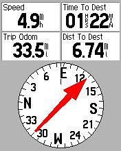
The arrow should always point in front of you, much easier to see than a very small black arrow on a map.
The 800 does not
I would imagine the newer etrex 20 and 30 have the same facilities.0