Garmin Edge 800

thegodplato
Posts: 319
Have just bought myself one and struggling setting it up properly as the manual is pretty naff. Any advice out there? I don't like the map at all as it seems to only show you the route you should be taking rather than the other roads around you as well. For instance if you need to turn off the road your on the route just turns left along the planned route and the road you were on that continues on just disappears!. Bet its me and there's an easy solution.
Its the basic model. Are there any better maps or anything to enhance it that I can download for free?
Help!
Its the basic model. Are there any better maps or anything to enhance it that I can download for free?
Help!
2012 Bianchi Via Nirone Xenon
960 miles in 8 days starting 6th April 2013
www.justgiving.com/teams/cyclemadness
cyclemadness.blogspot.co.uk
960 miles in 8 days starting 6th April 2013
www.justgiving.com/teams/cyclemadness
cyclemadness.blogspot.co.uk
0
Comments
-
Road signs.0
-
Sounds like you're using the base maps, which are sh*te. I use the OS maps, but you can get the city maps as well. They're far better than the base maps. There are free Open Source maps, I think one that comes up on here a lot is called velomaps, try googling it.
As for the instructions, I found the unit fairly self explainatory, so I just went into every menu to find out what it did. You're unlikely to screw anything up.Science adjusts it’s beliefs based on what’s observed.
Faith is the denial of observation so that Belief can be preserved0 -
thegodplato wrote:Have just bought myself one and struggling setting it up properly as the manual is pretty naff. Any advice out there? I don't like the map at all as it seems to only show you the route you should be taking rather than the other roads around you as well. For instance if you need to turn off the road your on the route just turns left along the planned route and the road you were on that continues on just disappears!. Bet its me and there's an easy solution.
Its the basic model. Are there any better maps or anything to enhance it that I can download for free?
Help!
Look at these links for good info
http://ridewithgps.com/edge_800
http://frank.kinlan.co.uk/garmin-edge-800/dummies-guide-to-the-garmin-edge-800/
http://www.bikeradar.com/forums/viewtopic.php?f=40012&t=12849481
Alternatively attend one of my free tutorials.
http://www.meetup.com/RichmondPark/events/56463682/0 -
MattC59 wrote:Sounds like you're using the base maps, which are sh*te. I use the OS maps, but you can get the city maps as well. They're far better than the base maps. There are free Open Source maps, I think one that comes up on here a lot is called velomaps, try googling it.
I downloaded some Opensource maps onto my own Edge 800 and they are definitely better than the base maps. Wish i had bought the proper OS Maps when i bought the unit in the first place! Still, the Opensource maps prove very useful and do give onscreen displays of the names of roads coming up next, as well as more detail than the base maps - certain enough to allow me to navigate around a 75 mile CTC ride last weekend with the instructions written down in text format0 -
Wirral_Paul wrote:MattC59 wrote:Sounds like you're using the base maps, which are sh*te. I use the OS maps, but you can get the city maps as well. They're far better than the base maps. There are free Open Source maps, I think one that comes up on here a lot is called velomaps, try googling it.
I downloaded some Opensource maps onto my own Edge 800 and they are definitely better than the base maps. Wish i had bought the proper OS Maps when i bought the unit in the first place! Still, the Opensource maps prove very useful and do give onscreen displays of the names of roads coming up next, as well as more detail than the base maps - certain enough to allow me to navigate around a 75 mile CTC ride last weekend with the instructions written down in text format
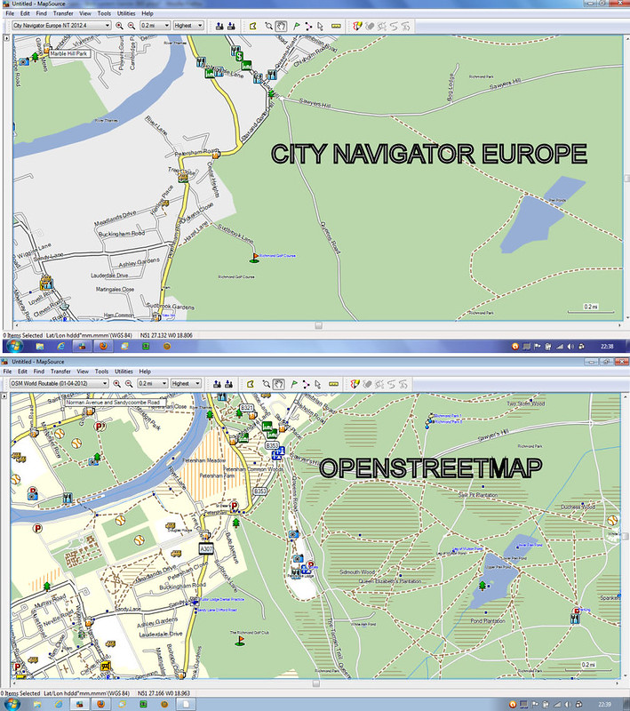
You will be disappointed if you think the "proper OS maps" will provide you with betterdetail than openstreetmap.
http://www.scarletfire.co.uk/2012/03/maps-comparison-city-navigator-and-os-discoverer/
http://farm9.staticflickr.com/8025/6957725908_717e05e1b9_b.jpg0 -
I got City Navigator off amazon about £25 I think. A lot better than the base map.0
-
0
-
Maps based on the Open StreetMap dataset, such as talkytoaster, velomap, open cyclemap etc, are becoming more and more of a serious contender as time goes by.
But their usefulness depends largely on where you live (or where you'll be riding). Many rural areas have not been mapped in great detail and I know from experience that whole sections of minor roads may not even exist on the map.
Fortunately it is not too difficult to edit the map and add new sections yourself, by using gpx tracks that you've created as guidelines for "drawing in" the roads.
If more people did this, osm mapping could rapidly make commercial products obsolete. Crowd sourced mapping has the potential to be more accurate and up to date, so what's not to like?
In the meantime, my advice would be to check the accuracy and completeness of the data in the regions you need, prior to deciding on whether it's a realistic option for you.Alan
http://www.scarletfire.co.uk
The Ultimate List of Strava Add On Sites!
http://www.scarletfire.co.uk/strava-sites0 -
What size MicroSD card do I need?
Thanks for the info!2012 Bianchi Via Nirone Xenon
960 miles in 8 days starting 6th April 2013
www.justgiving.com/teams/cyclemadness
cyclemadness.blogspot.co.uk0 -
thegodplato wrote:What size MicroSD card do I need?
Thanks for the info!
I think the talkytoaster OSM is a little over 2Gb. I have an 8Gb card, which is big enough for city navigator, os discoverer, and the talkytoaster.
You can get a good quality, fast 4Gb micro SD card for about a fiver from play.comAlan
http://www.scarletfire.co.uk
The Ultimate List of Strava Add On Sites!
http://www.scarletfire.co.uk/strava-sites0 -
freezing77 wrote:Wirral_Paul wrote:MattC59 wrote:Sounds like you're using the base maps, which are sh*te. I use the OS maps, but you can get the city maps as well. They're far better than the base maps. There are free Open Source maps, I think one that comes up on here a lot is called velomaps, try googling it.
I downloaded some Opensource maps onto my own Edge 800 and they are definitely better than the base maps. Wish i had bought the proper OS Maps when i bought the unit in the first place! Still, the Opensource maps prove very useful and do give onscreen displays of the names of roads coming up next, as well as more detail than the base maps - certain enough to allow me to navigate around a 75 mile CTC ride last weekend with the instructions written down in text format
You will be disappointed if you think the "proper OS maps" will provide you with betterdetail than openstreetmap.
http://www.scarletfire.co.uk/2012/03/maps-comparison-city-navigator-and-os-discoverer/
http://farm9.staticflickr.com/8025/6957725908_717e05e1b9_b.jpg
I cannot figure how someone could be disappointed by using OS maps. They are for different purposes! If you want a street map, like an A-Z then an OS map is not going to achieve that. An OS map, if you know how to use them, provides a totally different level of information.Plymouthsteve for councillor!!0 -
We are talking bike computers here. As a user of paper OS maps I think that they are great. But on a bike computer/gps like the 800 just when you need the level of detail as seen on the paper maps the screen starts becoming pixellated and unusable.0
-
I think you've missed the point. The level of detail of OS (as I have on my Memory Map 2800) is excellent for route mapping or indeed route recording and it's when it's at desktop that it's brilliant. For ride scoping, when you're not charging around like an idiot, it's also fantastic. Speech/instructions etc. all make up for not having a widescreen GPS or a handlebar mounted pack with an OS map under the PVC cover!Trail fun - Transition Bandit
Road - Wilier Izoard Centaur/Cube Agree C62 Disc
Allround - Cotic Solaris0 -
so I've just been to openstreetmap.org and can't see any link to download software. Is that the wrong site?2012 Bianchi Via Nirone Xenon
960 miles in 8 days starting 6th April 2013
www.justgiving.com/teams/cyclemadness
cyclemadness.blogspot.co.uk0 -
lostboysaint wrote:I think you've missed the point. The level of detail of OS (as I have on my Memory Map 2800) is excellent for route mapping or indeed route recording and it's when it's at desktop that it's brilliant. For ride scoping, when you're not charging around like an idiot, it's also fantastic. Speech/instructions etc. all make up for not having a widescreen GPS or a handlebar mounted pack with an OS map under the PVC cover!
OS maps on the memory map 2800 and the garmin 800 are chalk and cheese. They bear no resemblance to each other.
I agree that on memory map they are great, on the garmin they are rather less that average.0 -
 0
0 -
which do you think is better - Strava or RideWithGPS? Before I took the plunge to get this 800, I was using MapMyRide on my phone which, obviously, drained the phones battery and I want to do longer rides and still be able to contact home if necessary.2012 Bianchi Via Nirone Xenon
960 miles in 8 days starting 6th April 2013
www.justgiving.com/teams/cyclemadness
cyclemadness.blogspot.co.uk0 -
Follow this link http://garmin.openstreetmap.nl/thegodplato wrote:so I've just been to openstreetmap.org and can't see any link to download software. Is that the wrong site?
From the europe pull down menu choose UK, presumably.
Enter your email, you will be sent a link to a page with several downloads. You probably only need two, first the *.img file to put on you sd card and the *.exe to load the maps into mapsource/basecamp etc.
To put the maps on the sd card follow the last paragraph on this page http://ridewithgps.com/edge_800
from point 3 onwards0 -
freezing77 wrote:
OS maps on the memory map 2800 and the garmin 800 are chalk and cheese. They bear no resemblance to each other.
I agree that on memory map they are great, on the garmin they are rather less that average.
Is that really a comparison of memory map vs garmin, or is it really OS 1:50K versus OS 1:25k?
#justaskingAlan
http://www.scarletfire.co.uk
The Ultimate List of Strava Add On Sites!
http://www.scarletfire.co.uk/strava-sites0 -
It is a comparison between the OS maps available for the whole of the UK on the garmin and the whole of the uk on memory map.
You are correct in that one is 1:50k and the other 1:25k but the garmin1:25k maps are only selected areas.0 -
Before I go out I plan my route using RideWithGPS. When I get back home I upload my data to Strava, simply because Strava has more users uploading and "competing" against each other on segments - it's fun. RideWithGPS have now introduced segments but Strava has a much bigger following.thegodplato wrote:which do you think is better - Strava or RideWithGPS? Before I took the plunge to get this 800, I was using MapMyRide on my phone which, obviously, drained the phones battery and I want to do longer rides and still be able to contact home if necessary.Summer - Canyon Ultimate CF SLX 9.0 Team
Winter - Trek Madone 3.5 2012 with UDi2 upgrade.
For getting dirty - Moda Canon0 -
If you look at http://ridewithgps.com/ on the home page it shows a group shot of Garmin's under the heading `if you ride with GPS`. One thing I don't like with the 800 is the same map shot shown on that webpage - it has the map and says SE to Snowdon. I'd prefer a screen like the older model shows in the picture `navigate a route`. Is that easy to do and can it be done if I upload some OS map, etc?2012 Bianchi Via Nirone Xenon
960 miles in 8 days starting 6th April 2013
www.justgiving.com/teams/cyclemadness
cyclemadness.blogspot.co.uk0 -
Any routable map can give you turn by turn instructions . I am guessing thats what you mean, personally I follow the line on the map on screen, this highlights turns with a broad white direction arrow.

Similar to this
Like this 0
0 -
yes thats it. How do you get that on your screen?2012 Bianchi Via Nirone Xenon
960 miles in 8 days starting 6th April 2013
www.justgiving.com/teams/cyclemadness
cyclemadness.blogspot.co.uk0 -
Genuinely makes you wonder what people used to do in the 'olden days'.
Maybe they even had to think.
Surely, this type of navigation system is terrifyingly over engineering the simple problem of going from A to B on a push-bike. Perhaps even taking some of the fun with it too.0 -
IIRC Tools (spanner icon), system, map, orientation, automotive mode.thegodplato wrote:yes thats it. How do you get that on your screen?0 -
jim453 wrote:Genuinely makes you wonder what people used to do in the 'olden days'.
Maybe they even had to think.
Surely, this type of navigation system is terrifyingly over engineering the simple problem of going from A to B on a push-bike. Perhaps even taking some of the fun with it too.
I think in general it is one of those things that when written down looks terribly complicated but in use is very simple.
The biggest problem is that the garmin documentation is useless and the menus are not particularly intuitive hence the many many web pages like this.
But personally I would still recommend the etrex series over the edge series for navigation purposes and vice versa for bike training.0 -
Right set it to Automotive but still don't get the white arrow.
Also, don't seem to be able to alter the map screen as it tell me to Go Northeast rather than Turn Right. The next line down has speed and heading which I want to change to be speed and distance. And when I zoom out it seems that north is the bottom of the device so the map is the wrong way round. Scrap that I changed Orientation to Map North Up and then back to Automotive and it seems to have rectified the north issue.
I have it set to :
Routing
Calculate routes for Bicycle
Guidance Method - On Road for Distance
Lock on Road - No
Recalculate - Prompted
Map
Orientation - Automotive
Auto Zoom - On
Guide Text - Always Display
Map Visibility - Auto2012 Bianchi Via Nirone Xenon
960 miles in 8 days starting 6th April 2013
www.justgiving.com/teams/cyclemadness
cyclemadness.blogspot.co.uk0 -
did you download the TCX from ridewithgps?
If so, try the GPX instead. This will cause the Garmin to calculate the route itself, and it will then generate the arrows etc in the way you want. It sounds like it's using the turn by turn directions included in a TCX file.
I could be wrong, but try it.....Alan
http://www.scarletfire.co.uk
The Ultimate List of Strava Add On Sites!
http://www.scarletfire.co.uk/strava-sites0 -
You need to turn on "Turn by Turn Directions"
Menu, Courses, select your course, spanner icon, Turn by Turn Directions, On.
You have to do this once for every course you follow, I've not found a way of turning it on by default.Summer - Canyon Ultimate CF SLX 9.0 Team
Winter - Trek Madone 3.5 2012 with UDi2 upgrade.
For getting dirty - Moda Canon0
