GPS phone basics

Mr Dog
Posts: 643
I'm considering dragging myself into the 20th century and buying a GPS enabled phone. However I'm an old duffer who knows little of these magic devices that fit into your pocket, so to that end may I have a little advice? (please be gentle I really am clueless!) :shock:
I currently reside in NE Scotland where the mobile coverage can be patchy.
First an foremost I want something that will prevent me from getting lost. If I stray deep into the hills will the phone loose its signal and be rendered useless? The Outdoors GPS app has pre loaded OS maps and optional add ons, will this app still work giving me map functions but no location?
If I'm off road I don't feel the need to have the thing constantly in view, however in the summer I have been known to wrap my ar@se in lycra and spin around the tarmac so that feature may be useful at certain times. Will this affect my 'data allowance' and battery life?
I have heard that some sites like Map My Tracks allow real time viewing of a rider on route. This function would be useful to allow the Mrs to know where I was so that she can either have tea ready or direct the rescue helicopter.
Are all phones alike or is the iphone the way to go?
Thanks for your help.
Why tidy the house when you can clean your bike?
0
Comments
-
GPS signals come from satellites, so you don't need mobile coverage. However I believe mobile phones can triangulate themselves via their connection masts which improves speed and accuracy. Neither of which cost anything by way of data.
Most handheld GPSs have a 'Home' option or can display your route. You can buy maps for mobile phones too. £££. Google mapping is free but you need a data connection ... it sounds like using a mobile phone GPS is more about getting the right software than the hardware. And you may need to be careful with battery life.0 -
Thanks craker. So the GPS will function in the mountains.. fantastic. Can I simply switch it on when I get lost and are they accurate?Why tidy the house when you can clean your bike?0
-
My (wristwatch) GPS quotes its accuracy as between 5m (excellent) and > 100m (poor). Normally I can review the route I've cycled and my tracked position is on the road, if not always on the right side!
Eg.
http://connect.garmin.com/activity/135557471
Mobile phones wont have the highest calibre GPS - do some research (OK that's what you are doing...) but even at 100m accuracy that's easily enough to rescue you. Not tempted by a standalone GPS then? Advantages such as battery life and accuracy. Do you need mapping? I've just checked ebay and Garmin etrex go for £30 ish and they are very capable (but they dont have maps).0 -
I wouldn't but a phone for the GPS alone much better to get a dedicated GPS unit.
- Maps are already on loaded into memory (many smartphones will require a constant data connection)
- Phone batteries whilst using GPS can often last just 2-3 hours
- GPS units often more accurate and get faster locks
That said, if you also want a phone for emailing etc than they can be a cost effective solution.....it's what I use0 -
Tempted by the Edge 800, but phones have so many extra features and Garmin maps aren't cheap. I like the look of OS maps, they have alot of detail. Handtec have some good offers but I get the feeling that a phone is not a million miles away from a stand alone GPS. Maybe I'm very wrong :oops: . Mapping is pretty high on my list, as is music to keep me going when times get tough. Oh its a phone too.. Also the Mrs could keep an eye on me to plan stuff around the family via an on line tracker. Knowing which way is home is a the biggest selling point.
Thanks for the help.. I'm slowly getting to grips with the subject.Why tidy the house when you can clean your bike?0 -
I've got a cheap android phone (ZTE blade) with GPS. Have a look at Endomondo for the GPS tracking and for the Mrs to check you are still moving etc, and for getting lost/checking where you are without needing a data connection, take a look at the various Openstreet map apps that are around (OsmAnd being the best I've found so far). You can download the map data to the phone so it works offlline, and openstreetmap has very good detail for the paths that I ride. I think that you can add more to the dataset if you like too (it being open and all that). The ZTE is a little slow for high res OSM.
As for battery life, I think it varies depending on what app you are using. Endomondo is pretty good, and I reckon if the phone has a decent amount of charge before you set off, you won't have any problems. Note that for the Mrs to be able to check where you are, you'll have to have data turned on.
Bloke at work uses a blackberry for similar (but I don't have one of those so I can't comment).0 -
I use a Blackberry 9800 & Endomondo and found the battery life to be fine, but I don't ride for more than 2hours at a time.
SWMBO has also started using Endomondo whilst out on her horse having seen the benefits of being able to track me and know where I am if I get carried away and not home as early as she expected") 0
0 -
I got myself a smartphone about a month ago for the same reason. Went for a Samsung Galaxy W on Android 2.3.
The best GPS app I've found so far is Maverick. It has a number of maps available (I'm using OSM) & when you view a map online it's automatically saved to the phone so you can view it offline.
I tried Endomondo, but prefered the Maverick interface & offline maps.
Also, I tracked my short trip to work using both apps. Maverick said it was 2.9km which agrees with Google & Bing maps, but Endomondo said it was 3.2km. :?0 -
I've got a HTC desire using endomondo, everything works great. If I get lost google maps great, brings up a little blue arrow showing the way I'm pointing. If I move the phone the arrow moves so I know which road to take etc.um .. . . . .0
-
+1 for the ZTE Blade/Orange San Fransisco - brilliant little phone the one I strap to the bike (wrapped in clingfilm :oops: ) and use Endomondo and Google MyTracks.
For letting the Mrs know where you are download Glympse -
https://market.android.com/details?id=com.glympse.android.glympse&feature=search_result#?t=W251bGwsMSwxLDEsImNvbS5nbHltcHNlLmFuZHJvaWQuZ2x5bXBzZSJd
you can send a link by text/email/post to facebook etc and it will show, to whoever you decide, your current position - you can also choose to include current speed. It can run in the background, so it will not download the maps of your location to your phone.
Also download https://market.android.com/details?id=es.prodevelop.gvsig.mini&hl=en you can download map tiles to the SD card, including OS maps, for offline use, then it just uses the gps signal.
Job done 8)
EDIT:: Scratch that Maverick looks ace, pity no pinch to zoom, but looks to be a lot better than gvsig mini - might need pro version for storing maps though?Dave0 -
Sorry guys I'm lost.... so the GPS function can be used as a stand alone device, not needing a phone WiFi signal, and if you have pre loaded maps it will not use any of your data allowance?Why tidy the house when you can clean your bike?0
-
Yup, the GPS works on a different system - the phone does all the work internally from signals to/from the satellites - completely free.
If you have preloaded maps of the area you are in/going to, then you will be able to pinpoint where you are without using any data. You may even be able to put your phone into flight mode to make sure, or switch of the data side at least.
Glympse reads your position using the gps and uploads your co-ordinates to the web - not a lot of data
The gvSig Mini can be put into offline mode to make sure that it does not download maps, and that will let you still use glympse, just minimise it after you send the message, not sure how to do that with Maverick, so maybe that is one up for gvSig.
Do you have a contract SIM, as far as I am aware T-Mobile and O2 do not charge if you go over your data limit, they just have options to restrict the speed of the connection.Dave0 -
Mr Dog wrote:Sorry guys I'm lost.... so the GPS function can be used as a stand alone device, not needing a phone WiFi signal, and if you have pre loaded maps it will not use any of your data allowance?
If using an android phone with Maverick you can just use it as a standalone GPS tracking device by using the airplane mode, I use maverick a lot, all I do is look up the place I am going on the OSM or Multimap (both similar) before I leave then I have the maps cached permenantly, when im out to save battery put phone in airplane mode then it will only use the GPS I get lock in around 10secs providing tree's and hills/cliffs aren't obscuring the view of sky (needs a fairly wide angle view) up to 90 secs if bad, I used to have the ZTE blade and in airplane mode that would easy last 3-4 hours my new phone, htc sensation, will last around 5 - 6 hours.
My latest idea is to buy a cheap androind phone Blade or some other second hand, install maverick and litterally just use it for a stand alone GPS device should be do-able for less than £100 with full free OSM maps !! cheap cheap !! 0 -
Thanks people, you have helped me understand the devices and saved me a packet. I was about to pull the trigger on an iphone 4 on a monthly contract, but it seems there are cheaper/better options. The Garmin Edge 800 caught my eye for a while but in the summer i spend most of my time on the road and its difficult to get lost where I ride.
Will research the phones and options. Why tidy the house when you can clean your bike?0 -
Try Giffgaff, not sure on coverage though. Also the zte blade is on orange, but costs nothing to unlockDave0
-
Where is best place to find OSMs to cache permenantly?Why tidy the house when you can clean your bike?0
-
If you decide to go with Android then I can recommend Oruxmaps. Allows offline maps and can track your heart rate if you have a BT HRM. I use a Zephyr HxM HRM and it all works very well.
I also use a separate BT GPS receiver (an old Holux GPSlim 236) and pair it with my phone as I find it is far more accurate and holds a signal much better especially in densely covered areas. My phone battery also isn't then drained quickly by its
GPS receiver allowing me to easily get well over 10 hours of tracking, live uploading of data and live map downloading.0 -
Interesting reading everyone's thoughts about this. I've gone through various apps on my phone, and recently took the plunge and bought a Garmin Edge 800.
I blogged about my experience in the hope that it might help to inform others.
http://www.scarletfire.co.uk/2011/11/getting-started-with-android-apps-for-cycling-part-1/
http://www.scarletfire.co.uk/2011/12/android-gps-apps-for-cycling-part-2-offline-maps/
http://www.scarletfire.co.uk/2012/01/garmin-edge-800-why-you-shouldnt-bother-with-custom-osm-maps/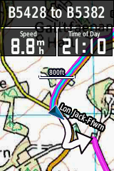
The last article is mainly about the pros and cons of trying to save money by going with the open source maps, or not. Hope it helps someone to make a better decision.
The garmin is awesome not only because of the mappng and navigation, but because of all the additional performance monitoring stuff, which can really help with a training plan. It's also a very robust little thing. I've cycled in torrential rain with it attached to my stem - something I would NOT want to do with my Samsung Galaxy S2!Alan
http://www.scarletfire.co.uk
The Ultimate List of Strava Add On Sites!
http://www.scarletfire.co.uk/strava-sites0 -
On the subject of data used, most GPS phones will by default be set to use A-GPS. This is Assisted GPS.
This uses a very small amount of data to connect to a server to quickly get the satellite almanac, which is basically a directory of satellites. In short, it makes the satellite fix time much quicker than getting the same data from the satellites.
You can turn off A-GPS usually somewhere in the phone settings. Doing so may make it take a fair bit longer to get a lock, especially in built up areas.
On top, phones now generally will provide a location without the GPS lock based on the cells and even known wifi locations if you are near a wifi access point. Some of this may or may not consume a bit of data. You can again turn these off. These location fixes are poor, but if you want a rough location it's okay.
Accuracy - worst thing about GPS, phone or otherwise, is elevation accuracy. Some apps are now trying to correct based on known ground elevations and there are ways of fixing the data yourself on a PC. Many dedicated GPS devices have a barometer however, and there are a few phones that have them too, but not many.
Pre-loaded maps on apps that doesn't consume data will require an app that caches maps or can download preloaded maps. Best choice for maps is probably ViewRanger but it's generally best for offline with the OS maps as those you buy and download to the phone to keep. It will cache OSM maps but you have to view the area first and even zoom in and out to the zoom levels you are likely to use.
Google Maps has an optional extra to pre-cache an entire area which is quite handy. Useless maps for off road however. Anything not on a road is often just blank.0 -
Have just taken the plunge with a Galaxy S2. Have downloaded a couple of apps. Now the fun starts when I try to understand this little box of tricks. I spent the best part of two hours trying to my get my music from windows multi media player onto the phone.. epic fail. Heaven knows how I'm going to figure out the GPS apps, guess I'll just have to find someone under 45 to show me how Why tidy the house when you can clean your bike?0
-
matt@theforce wrote:I use a Blackberry 9800 & Endomondo and found the battery life to be fine, but I don't ride for more than 2hours at a time.
SWMBO has also started using Endomondo whilst out on her horse having seen the benefits of being able to track me and know where I am if I get carried away and not home as early as she expected
I've just downloaded Endomondo for my Blackberry, looks very impressive and i cant wait to give it ago.
It does try to spam all your contracts (works phone) however when first logging into the app.
Does this programme work with Strava that seems to be popular?0 -
Galaxy S2 is like anything that isn't locked down like Apple & MS products, just plug into the computer and drag'n'drop your music files to whatever folder you want on the phone just using (if on Windows) Windows Explorer. Simple. No need to install special software, no messing around with Windows Media Player or god awful itunes and doesn't try to convince you to buy things from them. It's just like an external drive.Mr Dog wrote:Have just taken the plunge with a Galaxy S2. Have downloaded a couple of apps. Now the fun starts when I try to understand this little box of tricks. I spent the best part of two hours trying to my get my music from windows multi media player onto the phone.. epic fail. Heaven knows how I'm going to figure out the GPS apps, guess I'll just have to find someone under 45 to show me how
Thing with the S2, and any Android device really, is try to resist the temptation to install any and every app you see. You'll get bogged down with useless crap, and some may harm the phone, consume a lot of battery, if not data, and some are even malware. Check carefully first before installing and pay attention to what permissions it wants.
GPS apps of worth - ViewRanger, Endomondo, Sports Tracker*, My Tracks, Map My Tracks, Strava. In addition to things like Google Maps which should be included on the phone.
* - not the 'by STL' app of the same name, but maybe that's okay, never tried it.0 -
deadkenny wrote:Thing with the S2, and any Android device really, is try to resist the temptation to install any and every app you see. You'll get bogged down with useless crap, and some may harm the phone, consume a lot of battery, if not data, and some are even malware. Check carefully first before installing and pay attention to what permissions it wants.
It's also very easy to flash custom ROM images and essentially replace the operating system to a leaner version without all the crappy bloatware that vendors insist on slowing down phones with. This is worth doing because it can significantly increase your battery life, because the phone will be running fewer background applications etc.
There are some great tutorials out there, but most people get nervous when they realise that this procedure will void your warranty.
http://www.cyanogenmod.com/devices/samsung-galaxy-s2 is a good alternative ROM to use.Alan
http://www.scarletfire.co.uk
The Ultimate List of Strava Add On Sites!
http://www.scarletfire.co.uk/strava-sites0