What's the steepest hill on your commute?

supertwisted
Posts: 565
After spending some time working it out online, mine is a rather pedestrian 7% gradient. It's gotten a lot easier with practice, but is still hard work mainly due to the fact that it's right at the start of my journey home so I have no time to warm up.
I'm hoping to go single speed over the winter months so I'm working on getting up it (plus another couple of 6% climbs) in increasingly higher ratios whilst not exploding my kneecaps.
I'm hoping to go single speed over the winter months so I'm working on getting up it (plus another couple of 6% climbs) in increasingly higher ratios whilst not exploding my kneecaps.
Less internal organs, same supertwisted great taste.
0
Comments
-
Broomfield Hill. I know it's over 10% and less than 20%.Mud - Genesis Vapour CCX
Race - Fuji Norcom Straight
Sun - Cervelo R3
Winter / Commute - Dolan ADX0 -
Total ascent for my commute must be at least 5ft, and at the most 6ft...
 FCN 2 to 80
 -
Broomfield, too. Although Dark Hill has a nasty ramp to it.FCN 2-4.
"What happens when the hammer goes down, kids?"
"It stays down, Daddy."
"Exactly."0 -
If a car is blocking the driveway I sometimes have to drop off the kerb. That's vertical.
There's also Vanbrugh Hill if I'm taking a detour which, from some random internet site (http://www.bikeradar.com/MTB/forum/view ... t=12667599) is apparently 17.4%, though it's hardly long.0 -
I've got a really short but sharp climb right at the end of my homeward commute - only about 150 metres or so I'd guess, but according to my garmin, touches 14%, and must be average 10% at least. It's a bit nasty after 20 miles, although nothing like the feeling of cranking up in the big (mtb) ring if feeling good 0
-
Depending on which why I go back, it could be the 'mild incline' from New Cross Road up Amersham Way (which isn't really a hill) or it could be the 17% monster of Benson Road/Canonbie Road.
It's often the former at the end of the week. 0 -
supertwisted wrote:After spending some time working it out online, mine is a rather pedestrian 7% gradient. It's gotten a lot easier with practice, but is still hard work mainly due to the fact that it's right at the start of my journey home so I have no time to warm up.
I'm hoping to go single speed over the winter months so I'm working on getting up it (plus another couple of 6% climbs) in increasingly higher ratios whilst not exploding my kneecaps.
Similar here - about 8 percent for half a kilometre straight out of my front door - though there is a short stretch that is quite a bit steeper than that. Wouldn't do it single speed but then the whole route is up or down so SS wouldn't suit anyway.
Another route takes me up a slightly shallower gradient but that is for a km. It isn't the gradient but how long it is that gradient for!Faster than a tent.......0 -
It depends on the weather.
If it is tipping it down I have a straightforward 3 mile flat commute.
If the weather is cooperating then I usually take this longer and more scenic route
http://connect.garmin.com/activity/95503155
No idea about the gradients though.None of the above should be taken seriously, and certainly not personally.0 -
Probably Lavender Hill (the Latchmere Road way) - so nothing to worry about really, maybe 10% if that.1985 Mercian King of Mercia - work in progress (Hah! Who am I kidding?)
Pinnacle Monzonite
Part of the anti-growth coalition0 -
Mr Plum wrote:Total ascent for my commute must be at least 5ft, and at the most 6ft...
Portsea island is as flat as a pancake, but the wind is a killer. I always enjoyed seeing the trees on Southsea Common that look like they have been attacked by a chainsaw.
Pity the image is so big as you can't see the full effect of what the wind has done to the tree. Click the pic to see the smaller versionFCN 3: Raleigh Record Ace fixie-to be resurrected sometime in the future
FCN 4: Planet X Schmaffenschmack 2- workhorse
FCN 9: B Twin Vitamin - winter commuter/loan bike for trainees
I'm hungry. I'm always hungry!0 -
Ignoring the bridges either Tower Hill or Church Road in Richmond. Pretty flat all the way. Sometimes I throw in a lap of the park or a blast up Nightingale Lane. How steep are Broomfield/Dark Hill at their steepest?"Mummy Mummy, when will I grow up?"
"Don't be silly son, you're a bloke, you'll never grow up"0 -
Keyser__Soze wrote:Ignoring the bridges either Tower Hill or Church Road in Richmond. Pretty flat all the way. Sometimes I throw in a lap of the park or a blast up Nightingale Lane. How steep are Broomfield/Dark Hill at their steepest?
I live on Church Road and it is the curse of my commute. Great first thing in the morning though 0 -
The ramp from the underground carp park at work is at least 20% if not a bit more.--
Chris
Genesis Equilibrium - FCN 3/4/50 -
The hills in the park are probably biggest / steepest. Although sometimes I go straight on at Putney Bridge and on up the hill to the A3 that's a fairly big long steep hill.--
Chris
Genesis Equilibrium - FCN 3/4/50 -
Sketchley wrote:The ramp from the underground carp park at work is at least 20% if not a bit more.
Oh you b'st'rd.
Mine was 14%. YOU ARE RUINING MY LIFE! :oops: 0
 -
MapMyRide categorizes 3 Cat5 hills on my route home. Trouble is, the category descriptions are pretty crap, though, to Rolf F's point, it's a combination of incline and distance that the categories come from.
I have a short section that is the only place I stand in the lowest gear but it gives me no heartache at all because it's all of 50 yards. Mt Eagle on the other hand is at the end of the ride and has a gradually increasing gradient and is dead straight so stretches out ahead of you.ROAD < Scott Foil HMX Di2, Volagi Liscio Di2, Jamis Renegade Elite Di2, Cube Reaction Race > ROUGH0 -
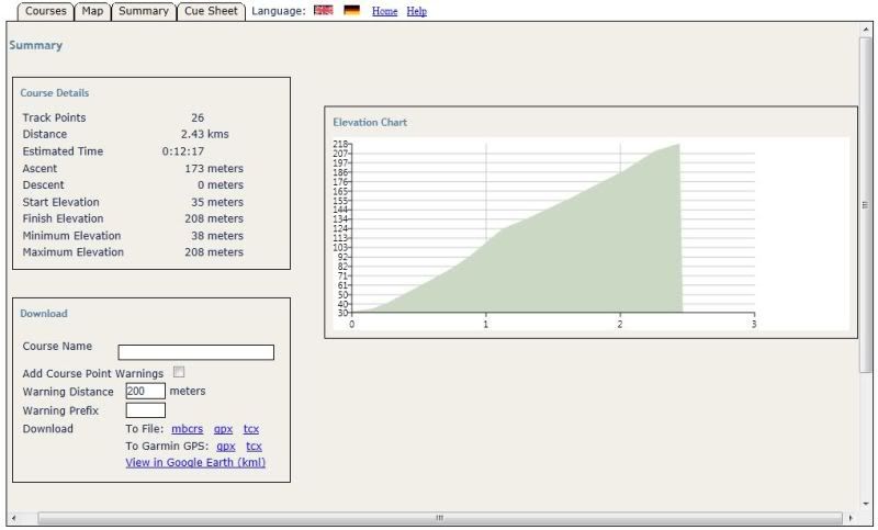
Hmmm. 13 metres elevation gain over 111m at it's steepest (11%), 22 metres elevation gain over 480m for the whole hill (5%).
It starts about 100 metres down the road from my front door, so despite being short and mild I always have to be really careful not to murder myself starting out in the morning.0 -
From your graph MT Eagle averages 3.2% (~210m over 6.5km)...meanredspider wrote:MapMyRide categorizes 3 Cat5 hills on my route home. Trouble is, the category descriptions are pretty crap, though, to Rolf F's point, it's a combination of incline and distance that the categories come from.
I have a short section that is the only place I stand in the lowest gear but it gives me no heartache at all because it's all of 50 yards. Mt Eagle on the other hand is at the end of the ride and has a gradually increasing gradient and is dead straight so stretches out ahead of you.
... which makes it a contender for a TdF Cat3 ...Invacare Spectra Plus electric wheelchair, max speed 4mph 0
0 -
EKE, did you take that photo of the trees? That is one great pic!0
-
More long than steep (long for me anyway)
 0
0 -
richVSrich wrote:EKE, did you take that photo of the trees? That is one great pic!
No, I found it on Google. It is of Southsea Common though. Geotagging of photos and uploading them to Google does have its uses after all.FCN 3: Raleigh Record Ace fixie-to be resurrected sometime in the future
FCN 4: Planet X Schmaffenschmack 2- workhorse
FCN 9: B Twin Vitamin - winter commuter/loan bike for trainees
I'm hungry. I'm always hungry!0 -
CAT 4 climb on part of my route, 1.3 miles long, 435ft gained
 0
0 -
Climb from Hinton up to the A46, 1.5 miles and 355ft
Although the main part of the climb is 0.9 mile and 312 ft reaching a max gradient of 17%
This is preceded by a small warm up.
Climbing up to Pucklechurch - 0.4 mile & 135ft with a max gradient of 16%
Always look forward to those two!?! 0 -
I'm claiming 20% for the steepest bit of my road commute. 30m height gain in 150m, my personal challenge is to stay above 6mph all the way up. The whole hill is approx 100m height gain, but there's a long flat bit.0
-
Some pretty horrendous climbs there, I'll have to remember them when I'm sweating up my paltry 7% hill. Less internal organs, same supertwisted great taste.0
-
I've a long steady hill - several different routes but got to get up it somehow.
Varies from 1:8 to 1:5 depending on which one I pick. The usual is 1:6 for about a mile. Fun on fixedCommute: Langster -Singlecross - Brompton S2-LX
Road: 95 Trek 5500 -Look 695 Aerolight eTap - Boardman TTe eTap
Offroad: Pace RC200 - Dawes Kickback 2 tandem - Tricross - Boardman CXR9.8 - Ridley x-fire0 -
Archway Hill on the way home. It might not be much but it is frequently enough.0
-
supertwisted wrote:After spending some time working it out online, mine is a rather pedestrian 7% gradient. It's gotten a lot easier with practice, but is still hard work mainly due to the fact that it's right at the start of my journey home so I have no time to warm up.
I'm hoping to go single speed over the winter months so I'm working on getting up it (plus another couple of 6% climbs) in increasingly higher ratios whilst not exploding my kneecaps.
The graph on bikehike for my usual route in shows a maximum up of 15% but the steepest down is over 20%
I expect that's why I use a different route home
Couple of years ago I was doing this on a 70" single speed
The hill that is "nothing like a continental climb but quite long thank you" is the B3170 from the motorway to the crossroads, 7km and 260 metres ascent, came home that way last night.0 -
is there an OS or similar website that will let me know the gradient of a particular stretch of road?
All I know is it's pretty steep, but it's over before I pass out :oops:wave your willy here !!!!") 0
0 -
A railway bridge is about as steep as it gets for me, around 6% for 50m :P0

