Cycling through France

daviddd
Posts: 637
I have a fancy to cycle down through France along the back roads in June / July, finishing up in the Alps to catch a day or two of Le Tour. Has anyone got any advice about possible routes / tips / what to see etc.? I particularly love the idea of exploring little sleepy villages with wee cafes in the sunshine by the village square,,, sigh..
Oct 2007 to Sep 2008 - anticlockwise lap of Australia... http://www.davidddinoz.blogspot.com/
French Alps Tour 2006: http://www.crazyguyonabike.com/doc/?o=r ... =1914&v=5R
3 month tour of NZ 2015... http://www.crazyguyonabike.com/doc/nz2014
French Alps Tour 2006: http://www.crazyguyonabike.com/doc/?o=r ... =1914&v=5R
3 month tour of NZ 2015... http://www.crazyguyonabike.com/doc/nz2014
0
Comments
-
Buy a Michelin Map and plan your own route. You cannot go wrong.Life is like a roll of toilet paper; long and useful, but always ends at the wrong moment. Anon.
Think how stupid the average person is.......
half of them are even more stupid than you first thought.0 -
dilemna wrote:Buy a Michelin Map and plan your own route. You cannot go wrong.
I second the advice about buying Michelin maps (or using the online maps on the viamichelin site).
My advice would be to avoid any road that's marked in red on the Michelin maps (ie routes nationales and some D roads). Michelin highlight scenic routes in green - I've always found these recommendations a help.0 -
I rode from north to south a couple of years ago, but used the train a few times to skip bits. My journal is here - it may give you some ideas...
http://www.crazyguyonabike.com/doc/?o=R ... =6304&v=kF
And here's a link to my journal that covers a ride from France over the Pyrenees to Barcelona...
http://www.crazyguyonabike.com/doc/?o=R ... 6355&v=1Ri
As suggested, get yourself a cheap Atlas of France - such as the Michelin one (try eBay) - and think of places that might appeal. I just picked out cathedral towns/cities as a way of marking out a beeline south.It's an uphill climb to the bottom0 -
ta for these links cycladelic - nice!Oct 2007 to Sep 2008 - anticlockwise lap of Australia... http://www.davidddinoz.blogspot.com/
French Alps Tour 2006: http://www.crazyguyonabike.com/doc/?o=r ... =1914&v=5R
3 month tour of NZ 2015... http://www.crazyguyonabike.com/doc/nz20140 -
avoid paris unless its a must visit or you have a well worked out route, we ended up doing several laps of CDG airport and the housing estates nearby, great fun. also Dijon is great! switzerland is EXPENSIVE if costs are an issue!
second what the others have said, see how the journey takes you! cant go wrongDMR Sidekick
BeOne Spirit 09
Diamondback Pacer 500
Identiti p45....frame
FCN - 7
Ride to Milan...DONE
Ride to Barcelona...ASAP0 -
drrastapopulus wrote:avoid paris unless its a must visit or you have a well worked out route, we ended up doing several laps of CDG airport and the housing estates nearby, great fun. also Dijon is great! switzerland is EXPENSIVE if costs are an issue!
second what the others have said, see how the journey takes you! cant go wrong
Erm....Switzerland.....
WTF did THAT come from? :roll:so many cols,so little time!0 -
-
We are a bunch of Old FB's who are about to embark on a west / east crossing of France from a beach near Bordeaux to Narbonne (ish) from 1st to 4th July. None of us can be classed as regular cyclists, but hey - you only live once! So far we have found Michelin maps to be pretty good and one of the guys is a devotee of Google maps and Garmin - related software.
In planning the route we are trying to avoid travelling on roads with a "v" gradient marker and also anywhere near "viewpoints" as these tend to be at the tops of hills.
Good luck with your journey.
Never know - we may cross paths!!
Anyone else got experience of west / east?0 -
you know, switzerland, that place in the middle of the alps...
was just a heads up, relax.DMR Sidekick
BeOne Spirit 09
Diamondback Pacer 500
Identiti p45....frame
FCN - 7
Ride to Milan...DONE
Ride to Barcelona...ASAP0 -
..the more I look at the map the more the mouth waters! Could head down the W coast via the Verte routes / canal, then through the Pyrenees and Alps (maybe La Suisse lol) back to Dieppe - shoudn't take longer than 2 months. Well, I don't have to work any more!Oct 2007 to Sep 2008 - anticlockwise lap of Australia... http://www.davidddinoz.blogspot.com/
French Alps Tour 2006: http://www.crazyguyonabike.com/doc/?o=r ... =1914&v=5R
3 month tour of NZ 2015... http://www.crazyguyonabike.com/doc/nz20140 -
I can strongly recommend 1:200,000 spiral bound Michelin atlas - just tear out the pages you need and take them with you - we found it had enough detail to navigate across France a few years ago. Plenty of other threads on this forum which we found useful when we were planning.0
-
if you are feeling lazy the 'tomtom' western europe app for you phone is investment worth considering, was about £50 last summer, we are crap map readers and take any excuse to use mcdonalds wifi!!DMR Sidekick
BeOne Spirit 09
Diamondback Pacer 500
Identiti p45....frame
FCN - 7
Ride to Milan...DONE
Ride to Barcelona...ASAP0 -
Definitely 1:125,000 Michelin map.
We checked the Tour dates and planned a coast to coast based on that...buy map, cycle, run out of map, buy map, cycle, run out of map...repeat as necessary! We planned to arrive in St Malo and depart from Montpellier...that was it...it was just fantastic.
I wish I could do this every year!
http://www.flickr.com/photos/10867118@N07/
cheers,
Alan0 -
HillheadHornet wrote:
Looks awesome! Trying to choose some panniers for a trip from London down to Switzerland and then possibly on down to Barcelona. I see you and your buddy have a mixture of what looks like Vaude Aquas and Ortleibs? How did you find them? Any preferences?Offroad: Canyon Nerve XC8 (2012)
Touring / Commuting: On-One Inbred (2011)(FCN9)
http://uninspiredramblings.wordpress.com0 -
My mate (pictured) used the Vaude and I used the Ortlieb...I've had the Ortlieb for about 11 years and can't recommend them highly enough. They are just superb. Well worth the investment. If anything, I think people question the price as a drawback. Apart from that I can't think of any others at all.
It would be unfair for me to comment on other brands. I would definitely go for the harder wearing thicker wax finish rather than other materials though - very robust and easy to clean. The ortlieb can be used as water carriers which also indicates something about the material/waterproofing construction!0 -
Ortlieb are practically bomb-proof - I used 4 of the large frontrollers for a year when cycling around Oz - they went through rivers and blazing sunshine for months and still as sound and leak proof as when new. A great investment.Oct 2007 to Sep 2008 - anticlockwise lap of Australia... http://www.davidddinoz.blogspot.com/
French Alps Tour 2006: http://www.crazyguyonabike.com/doc/?o=r ... =1914&v=5R
3 month tour of NZ 2015... http://www.crazyguyonabike.com/doc/nz20140 -
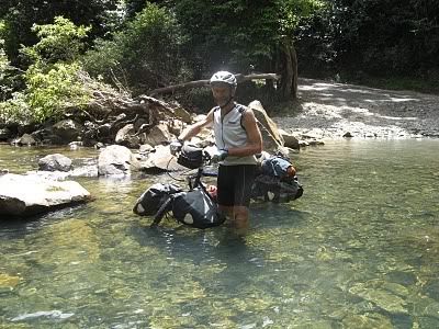
...like this...
 Oct 2007 to Sep 2008 - anticlockwise lap of Australia... http://www.davidddinoz.blogspot.com/
French Alps Tour 2006: http://www.crazyguyonabike.com/doc/?o=r ... =1914&v=5R
3 month tour of NZ 2015... http://www.crazyguyonabike.com/doc/nz20140 -
canal du midi
and other canals are a great way of getting down the west side....through Toulouse Carcassone etc
george0 -
at Millau through the Gorge du Tarn ...under that amazing bridge.....then Nimes Avignon etc etc etc0
-
Hi, I am planning on doing something simmilar heading out end of May till end of June. I was thinking of getting a Garmin 705 but am put off by the cost, would a decent map really do the job? All I have planned is to head to Lyon then play it by ear after that so thought maybe GPS was the way to go.0
-
Yossarian82 - What happens if/when the batteries die?
You can't go far wrong with a Michelin map and a compass.It's an uphill climb to the bottom0 -
Well I would not have gone totally mapless of course if such an eventuality occured, my query was more is a GPS system totally necessary as it seems many people get along fine without one. I am only concerned as going alone and the GPS would feel like a bit of a safety net maybe.0
-
cycladelic wrote:Yossarian82 - What happens if/when the batteries die?
head off into the Office de Tourism and get free maps of the region and department..
lots of local detail and information
george0 -
Yossarian82 - I manage okay wihout one. If you don't already have one, just forget about it - I'm sure you'll be fine in France. GPS is useful in an urban area when looking for places to eat and sleep, but as you're camping, a map should do the job. And as Jibi says, you can get some free info' from tourist offices en route.It's an uphill climb to the bottom0
-
daviddd wrote:...like this...
I take it that you have dissembled and cleaned your hubs and BB following this.
I would have gone to great pains to avoid submerging my bike to this extent.
Good luck with your trip.0 -
Living here and having cycled most of France, my advice would be to keep off the main roads and you will be amazed at the lack of traffic and the breathtaking scenery. However, be warned take ample supplies of water and food as distances between villages/towns can be large, and even then there is no guarantee that a bar/cafe will be open. The road surfaces nowadays are good even after a couple of hard winters, not too many pot holes. You will find most other cyclists friendly and helpful in times of difficulty.
Have a good trip - keep spinning.
www.charitytours.orgCharity Tour de France 2011 ~ The Prostate Cancer Charity. See more at http://www.charitytours.org0 -
+1 for Michelin; much better than IGN I've always thought, more realistic.
The latest Michelin maps are 1/150 000 which seem to have replaced the old yellow 1/200 000. They are great but are sold in sheets covering two adjacent départements (but are smaller therefore lighter). I don't recall ever seeing regional variants like there were with the 1/200 000 series. Learn to recognise the line thicknesses which give an idea of the traffic density and use only uptodate maps, the road numbers change from time to time, although road renumbering should be just about finished by now.
On a bigger scale Michelin have 1/300 000 regional maps which are great for planning or getting to your preferred area. I have Rhone-Alpes sitting in front of me, it covers from north of Mâcon and Genève to south of Digne-les-Bains and into the Côte d'Azur and from the Auvergne in the west to the Swiss and Italian borders. The detail is sufficient to avoid busy roads but you need very good eyes or a very powerful magnifier to use these maps for navigating, the design isn't brilliant.
I would definitely not waste your time woth a GPS unless it is the IGN specific one (in which case you will be spending serious money and trail riding). GPS is fine when you don't need it but likely to mess you up when you do.
I would go for buying only the first map that you need to get off the ferry before you go. You can plan with google or michelin on the web. Maps are readily available, buy what you need as you go along and post them home when you've finished with them, saves weight and the risk that they'll be destroyed in a downpour. You could even rely totally on freebies out of tourist offices but they are sometimes very local and the better ones are no longer free!
Welton I don't know what region you live in but rest assured, the road surfaces in Limousin have deteriorated quite noticeably in the last 4 years due to a combination of hard winters, lack of maintenance and overuse of diesel in motorcars.
Happy touring everybody. Cheers Jo0