Langsett Resevouir (South Yorkshire)
matt@theforce
Posts: 647
Had a blast around this route last week, was a lovely clear sunny friday morning so I took the long route
Route http://recreation.yorkshirewater.com/?PT=Y&OBH=3754&ID=299
I did the route backwards knowing what the path down to Brook House Bridge was like (gave me something to really look forward to)
North America looking over the resevouir

Half way between point 6 & point 5


Looking from point 5 towards point 4

Top of Hingcliff Hill looking back towards point 5

Was a great little ride around 8 miles from the car park back to the car park although I only live a couple of miles from there so still had a little extra to add onto the ride
Matthew
Route http://recreation.yorkshirewater.com/?PT=Y&OBH=3754&ID=299
I did the route backwards knowing what the path down to Brook House Bridge was like (gave me something to really look forward to)
North America looking over the resevouir

Half way between point 6 & point 5


Looking from point 5 towards point 4

Top of Hingcliff Hill looking back towards point 5

Was a great little ride around 8 miles from the car park back to the car park although I only live a couple of miles from there so still had a little extra to add onto the ride
Matthew
0
Comments
-
We did it as a (very windy)night-ride a couple of Saturdays ago but also do it in reverse 8)
If doing in reverse it's well worth turning left at point 5 and go up and over Cutgate down to Howden reservoir,turn around climb back up to the top of Margery Hill then blast back down to Langsett woods.Classisc ride
8)0 -
the peaks look dry compared to the nym we did on sunday,i brought home half the moors on my tyres.......i may be wrong but we also do that route in reverse,including the bit ibbo said,climb back up margery hill is normally a push for me tho....and didnt realise it was mapped out the other way round by yorkshire water.0
-
Did a variation of this ride from Langsett car park up over Cut Gate and down into Fairhomes and back. It was very muddy up over the top of Cut Gate on Sunday and seemed hard going

Back out this weekend, but think we will give Cut Gate a rest as its getting a bit of a mess on sections I had not previously seen turned to a muddy mess.
Nice ride and pictures though, your lucky to live so close! 0
0 -
Not sure I could cope with anymore uphill sections at the moment, my legs were very tired by the end of this ride and with the climb over the hill to Millhouse Green (home) that finished me off. By the time my shift patterns move back to days off in the week I should be a little fitter and will give it a try.ibbo68 wrote:We did it as a (very windy)night-ride a couple of Saturdays ago but also do it in reverse 8)
If doing in reverse it's well worth turning left at point 5 and go up and over Cutgate down to Howden reservoir,turn around climb back up to the top of Margery Hill then blast back down to Langsett woods.Classisc ride
8)
I had to push the bike up a fair chunk of this from North America, I don’t have the stamina to keep peddling but refuse to get off and sit down for a rest, I’ll get off but keep walking then hop back on for a short while.altern_8 wrote:the peaks look dry compared to the nym we did on sunday,i brought home half the moors on my tyres.......i may be wrong but we also do that route in reverse,including the bit ibbo said,climb back up margery hill is normally a push for me tho....and didnt realise it was mapped out the other way round by yorkshire water.
SWMBO and I had taken our sons for a walk down there and noticed on one of their signs in the car park that Yorkshire Water had made some maps up online, I suppose they mapped it out this way to give you a steep climb rather than a steep decent.hoochylala wrote:Did a variation of this ride from Langsett car park up over Cut Gate and down into Fairhomes and back. It was very muddy up over the top of Cut Gate on Sunday and seemed hard going
Back out this weekend, but think we will give Cut Gate a rest as its getting a bit of a mess on sections I had not previously seen turned to a muddy mess.
Nice ride and pictures though, your lucky to live so close!
Thankfully the ground was OK due to the very cold temperatures overnight, it was -1 when I left home and half way up the hill I noticed the water in my bladder tube was starting to freeze. All of the streams & boggy parts were all frozen over which gave me a little scare coming down towards Langsett as I was carrying quite a bit of speed when I noticed the frozen stream I was about to fly over.
Have to say, I’m loving this bike. You can take it out and have a good hard ride then use it later that day for commuting to a colleges house on the way to work without changing/adjusting anything, it truly is an all round bike.0 -
I did the night ride with ibbo, was a struggle to stand in the full force of the wind.
It is indeed a classic ride, although I too now think it best if avoided unless it either freezes hard or we get a long dry spell. Parts of it are just a quagmire, and we're now also avoiding Whinstone Lee torr for the same reason.0 -
ratty2k wrote:Iand we're now also avoiding Whinstone Lee torr for the same reason.
whinstone lee torr needs about 3-4 months of warm dry weather,and also needs a roller over it(which wont happen) to flatten it out abit.......and youre right ratty,cut gate is a bitch if wet,first time we rode it was during a summer,a couple of years ago,it was still under a foot of nice black water,first time last year we got it bone dry,and was a classic.....still aint found the "steps" near there tho,lol0 -
You mean the steps on the Cutgate ride?Easy to find...even easier to missaltern_8 wrote:still aint found the "steps" near there tho,lol 0
0 -
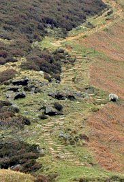
Not sure I've heard that name but there are 2 sets of steps just as you descend off Cranberry Clough(Howden edge) towards Slippery Stones
 0
0 -
ibbo68 wrote:Not sure I've heard that name but there are 2 sets of steps just as you descend off Cranberry Clough(Howden edge) towards Slippery Stones

i think thats the one "slippery stones"like i said,dont ask me why i had fairy steps in my head
are the slippery stones in the woods when you get to the bridge at the bottom of cranberry clough?0 -
Nah.altern_8 wrote:are the slippery stones in the woods when you get to the bridge at the bottom of cranberry clough?
Slippery Stones are underneath the stone Packhorse bridge at the top of Howden Reservoir.They're like stone slabs that used to be the only means to cross the stream before the bridge was re-located in 1959.The bridge is 17th Century and was taken down when Derwent and Ashoption villages(Ladybower)were flooded to create the reservoirs it was then re-built at slippery stones to make crossing easier.So it's still called slippery stones or slippery stones bridge.
The only steps on the route are on the steep decent of Cranberry Clough.0 -
-
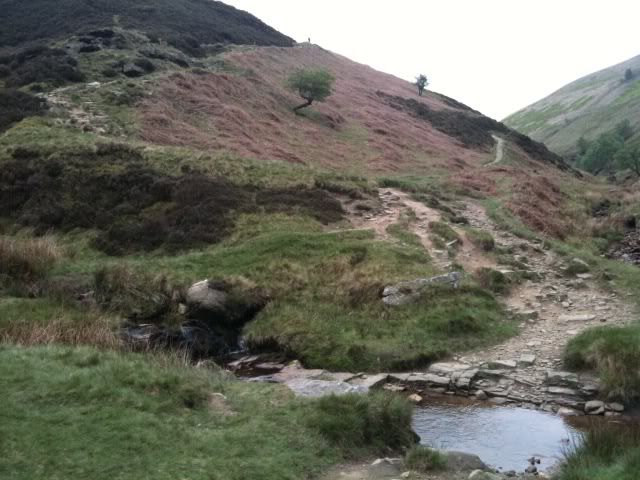
Yup that's the 2nd(bottom set) and not for the faint hearted!There's also a 1st(top set) about 100m further up.Easy to spot on the climb up harder on the fast descent.
If you look carefully at the photo there's a post sticking up where the top trail goes out of shot(directly above the Rowan tree)the top set of steps come out across from the post.
Here's a better photo of the bottom steps: 0
0 -
i think the reason i said about the stones being in the woods is,that on the os map we have,it says slippery stones are in the woods,so miss-took they are there :roll:
like this>>>http://www.mountainbikerides.co.uk/index.php?option=com_content&view=article&catid=1:the-peak-district&id=18:doctors-gate-a-cut-gate-path&Itemid=20 -
Ay,'tis a bit missleading :roll:
I think it happens in general on OS maps a marker or arrow would help.0


