Rides from Briancon

inaperfectworld
Posts: 219
I'm spending some time here, mainly because I wanted to do the Izoard. I've seen Col de Granon but wonder about the road surface judging by the map markings it looks a bit suspect. I am also looking at north from Briancon to Bardonecchia via Col l'Echelle; this could be made into a circuit taking the S road south to Ouix then to Cesana Torinese and Col de Montgenevre back to Briancon. The Italian section looks like it mostly busy roads and not much fun. There is also a climb South of Briancon a tL'Argentiere to Vallouise and on toAilefroide and finally Pré de Mme Carle. Anyone know about these?
0
Comments
-
The east side of the Granon isn’t asphalt-paved, and although it’s fairly fine gravel and stone near the top, farther down it’s big and coarse gravel and stone, not for road bikes at all. People drive up to the Granon to then do day-hikes, so maybe avoid Sunday.
If I were doing a circuit including Echelle and Montgenevre, I think I’d do it anti-clockwise, not clockwise as you suggest, because then slightly less time is spent climbing on the (often very) busy road – from Briancon to the top it’s about 12 km but from Oulx to the top about 20 km.
Or, instead of the circuit I’d be tempted to do two out-and-backs, one via Echelle to Bardonecchia and back, and one via Montgenevre to Sestriere and back. The climb up to Sestriere from Cesana Torinese is often used in the Giro (and occasionally in the Tour too), so perhaps belongs to those climbs everyone interested in professional racing should do at least once.
I don’t know the road up to Pré de Mme Carle, but there’s a mountain hut there and in summer people drive up to then hike from there – again maybe avoid Sunday.
From Vallouise, you could also do the climb up to the ski station Puy St. Vincent, which has also been used in the Tour.
Getting to/from L'Argentiere, I’d avoid the main road between Briançon and Guillestre, and use the parallel minor roads, especially when heading ‘upstream’, so in the G to B direction.
Nearer Briançon, the Col du Gondran (roughly parallel and east of the west side of Montgenevre) is an adventure worth trying. A military road barred to motor vehicles, and not in the best condition for road bikes, the climb up from the SW (Briançon) is nonetheless worth it for the view, the peace and the experience. The descent to the NW (village of Montgenevre) isn’t always paved and means walking a bit, especially higher up,, but it’s safer than riding the way up back down to Briançon because of the narrowness and drop-offs (see pic).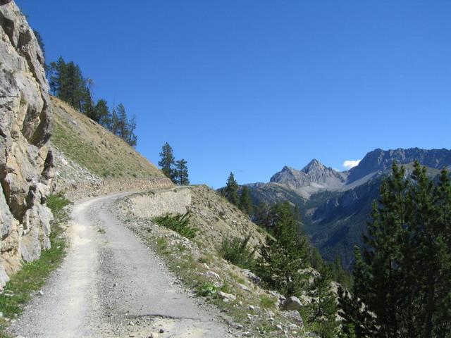 0
0 -
Nedlicky that's great info thanks0
-
We rode the Col Du Granon in 2008 from Saint Chaffrey which is 2 miles outside Briancon on the D1091. It is apparently the steepest mountain top finish ever used on the tour, last used in late eighties or early nineties.
The road surface is fine from this side, but it is consistently steep, average 10% for 11km if I remember correctly.
I have some photos of the road and the summit if you send me a pm with email address I can send them.0