Bike route fibbers!
rolf_f
Posts: 16,015
Did a couple of circuits of a nice little route around Great Ouseburn, Borough Bridge and Aldwark Bridge NW of York this weekend. Nothing too long - the route is 22 miles long and chosen to be not too hilly so I could concentrate on speed and sprint bursts for those all important fast twitchers (hark at me, proper pro I sound  ).
).
Anyway, much as I like the Bikely interface, I can't get on with the fact that a) if I click on a location at one end of a N Yorks Village and next on a location at the other end of the village, rather than linking the two points, Bikely thinks that those two clicks means I actually want the quickest route to Oslo and b) to get rid of the route to Oslo, I have to press the delete point button 27,548 times to get back to where I was.
So, I tried Bikeroutetoaster which, whilst much more irritating to use, does actually have a useable route find and a sensible undo function.
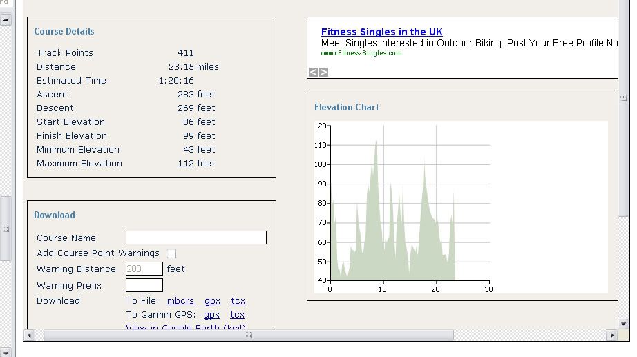
So, I plotted the route and this is what I got.

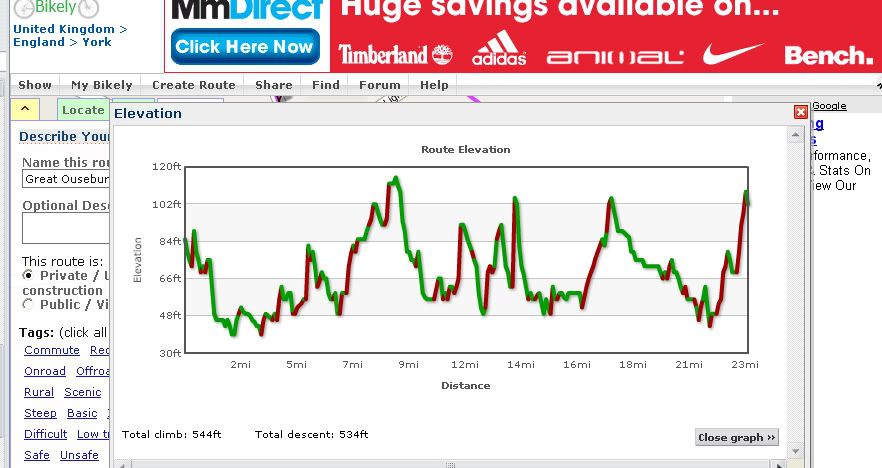
This is the same route plotted in Bikely (without deviation to Oslo)

Anyway, much as I like the Bikely interface, I can't get on with the fact that a) if I click on a location at one end of a N Yorks Village and next on a location at the other end of the village, rather than linking the two points, Bikely thinks that those two clicks means I actually want the quickest route to Oslo and b) to get rid of the route to Oslo, I have to press the delete point button 27,548 times to get back to where I was.
So, I tried Bikeroutetoaster which, whilst much more irritating to use, does actually have a useable route find and a sensible undo function.
So, I plotted the route and this is what I got.

This is the same route plotted in Bikely (without deviation to Oslo)

Faster than a tent.......
0
Comments
-
profiles not that different, but for a few random spikes, but the data is very different. Have you tried memory map software? It runs off OS data and is pretty accurate in terms of distance, profile and height gain.0
-
There's loads of these sites about. If you could take the best bits of all of them it'd make an excellent site, but at the moment they all seem to have issues.
On elevation, Bikely (when it works), is usually under by 10-15% in the UK. For some reason it's over in the european mountains.
Bike route toaster is quite a bit over, although I've not measured on a number of courses.
(this doesn't match the data you have, so now even more confused!). 0
0 -
Just buy memory map! It is frankly a fantastic product and the ability to view terrain in 3d makes route planning great, whether you are trying to find the hills or avoid them! Printing maps and downloading GPS traces/uploading routes is a doddle. I have central and northern england and some specific bits of wales where I do a fair bit of riding, its brilliant.0
-
As soon as google adds a "cycle" option to its maps software all of these sites are dead.0
-
google doesn't use OS data though as far as I am aware (its high scale maps are dreadful), so it has no height info to work from.0
-
salsajake wrote:google doesn't use OS data though as far as I am aware (its high scale maps are dreadful), so it has no height info to work from.
The height data doesn't have to come from the OS. There are plenty of sources of digital terrain map (DTM) which is what these mappers use.
I'm intrigued by TheStones comment about the mappers being over height in Europe. By definition, you'd expect all these calculations based on DTMs to underestimate height climbed unless they use some algorithm to compensate for the error (the DTMs are gridded and the accuracy of the height calc will depend on the resolution of the grid - generally they are pretty course. The Bikeroutetoaster section above is displayed very badly but may be a little coarser than the Bikely one. Probably though they are the same. The DTM in Google Earth is very coarse).
Salsajake - I'll look at memory map but probably not until I get a GPS which won't be until sometime after I have my new bike which won't be for some time from now!Faster than a tent.......0 -
agree they come into their own with a gps, especially for exploring local roads on a shortish to medium blast when you don't want to get the map out all the time and can't afford the time to get lost (though it is sometimes nice to ride off and get lost and then try and work your way home)0

