Website For Calculating the Flattest Route ?
seataltea
Posts: 594
In a few days I'll be commuting to an alternative workplace which is somewhat further than my usual commute.
Is anyone aware of a web based route finder which as well as providing routes will calculate ascents and descents ?
In simple terms I don't mind adding a mile or two to the journey but want to keep it as flat as possible.
Thanks
Is anyone aware of a web based route finder which as well as providing routes will calculate ascents and descents ?
In simple terms I don't mind adding a mile or two to the journey but want to keep it as flat as possible.
Thanks
'nulla tenaci invia est via'
FCN4
Boardman HT Pro fully X0'd
CUBE Peleton 2012
Genesis Aether 20 all season commuter
FCN4
Boardman HT Pro fully X0'd
CUBE Peleton 2012
Genesis Aether 20 all season commuter
0
Comments
-
I use mapmyride.com. it's free to register, and is generally pretty good. The one major issue is that it averages gradients over a dozen segments or so irrespective of route length. I find it's generally more accurate if you look at the route in small portions.pain is temporary, the glory of beating your mates to the top of the hill lasts forever.....................
Revised FCN - 20 -
+1 on bikehike but be aware that any online mapping site using google data will be wildly out when it comes to elevations, however you can pretty much tell how hilly it's going to be by switch to terrain mode and looking for the bumps and folds.
Good luck.Rule #5 // Harden The Feck Up.
Rule #9 // If you are out riding in bad weather, it means you are a badass. Period.
Rule #12 // The correct number of bikes to own is n+1.
Rule #42 // A bike race shall never be preceded with a swim and/or followed by a run.0 -
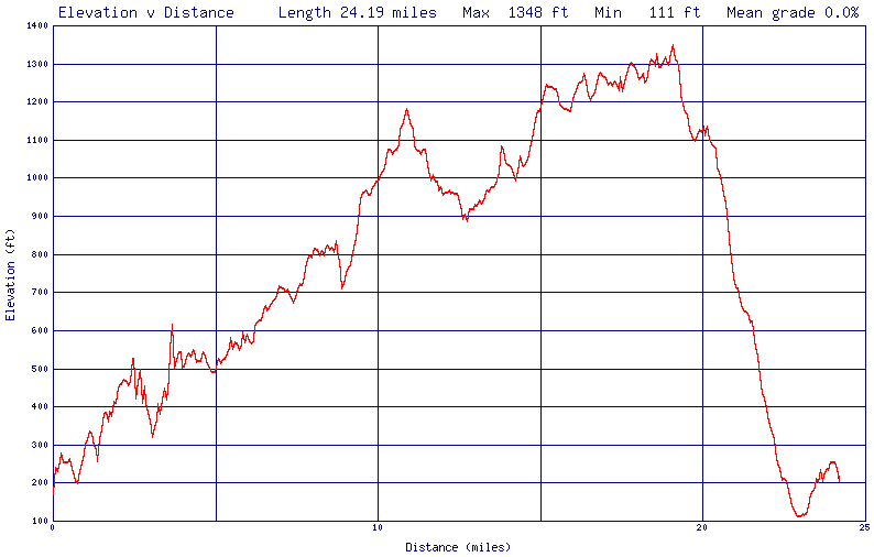
toporoute gives you a graph detailing the altitude - here's an example (a ride I did on Dartmoor last summer):
 0
0 -
MTFU!0


