Which Garmin for touring?

GyatsoLa
Posts: 667
Two questions here on using GPS for touring (I've been mulling over getting one for a while, but they are 20% off now on wiggle so its as good a time as any to make the plunge).
1. Any advice on whether the Garmin Edge 705 or the Garmin Legend eTrex? This article on crazyguyonabike:
http://www.crazyguyonabike.com/doc/page ... 67514&v=66
recommends the eTrex with a bike mount, but various mag reviews opt for the Edge as its more bike friendly. I'm tempted by the bike specific extras on the Edge (such as heart rate monitor), but realistically I'll mostly be using it for touring, so the eTrex seems to be a little more practical.
2. Any experience with sources of good downloadable maps for Asia? I have forthcoming tours planned for Taiwan and Japan, but the main download resources I've seen (such as www.memory-map.com) don't seem to have any maps for them. I'd hate to get it and find I'm depending on very poor quality maps, which sorts of negates the whole point.
Any comments gratefully recieved, as usual....
0
Comments
-
I agree with the crazy guy.
When people talk about the Garmin 705 etc being 'bike-specific' I think they are generally talking about the fact that it has the options of cadence meters etc. The 705 is targetted as a training aid while the eTrexes are for more specific navigation. It's worth comparing the specs on the Garmin website. The 705's features are very clearly targetted on 'fitness' users while the features of (say) the Legend HCx are more general.
The key differences in the features from the perspective of the touring cyclist are the ability to add 'waypoints' (eg places to stay, water, key junctions) and the ability to store tracks so you can see where you have been. (Of course you might decide you aren't interested in either but it's worth knowing they are there). The Edge will store 100 waypoints while the eTrex will store 1000. The eTrex will store 10,000 track points while Garmin don't specify the number of trackpoints stored by the Edge.
For the eTrexes you have buy a bike mount for about £12. The bike mounts are beautifully engineered and the eTrexes work perfectly on a handlebar (though I did meet one guy who managed to wreck his by landing a jump badly but so so long as you remember to take it off before doing jumps you should be fine).
The Edge looks like a nice gizmo, and I can see that if you were training seriously then the ability to have all of your stats in one place and be able to download in one go is a definite plus. But if not then they look pretty pricey in comparison with the eTrexes. In fact you could get an eTrex Legend HCx and a decent bike computer/cadence meter, and a decent HRM and still save money compared with buying an Edge.
For some reason the prices of the colour display models have fallen relative to the prices of the monochrome display models. The monochrome display models are really very poor value for money in comparison. I wouldn't bother with a barometric altimeter or electronic compass.
As far as the mapping is concerned. It would be worth searching around - it's surprising what you can find with a bit of digging (eg free topographic mapping of most of the Western US, Spain and Portugal). If you are planning on doing road touring then you could fall back on the road mapping sold by Garmin. You may find that there is some world mapping bundled with the GPS (I've just been looking at the US basemap which includes surprisingly detailed road mapping for Japan and China). for more detailed mapping you can also purchase add-ons. (I know that road mapping isn't as good as topographic mapping but it may be all there is). It could well be worth asking Garmin or the map-shop.co.uk (I think that's the URL).0 -
What andymiller didn't mention is that the Etrex uses AAs, but that the 705 has a built-in rechargeable battery. This means that you have to find mains electricity every night. Whilst you may be willing to risk a set of AAs and a cheap charger unattended in a campsite toilet block or YH dorm, the same probably doesn't apply to a 705. There's also the point that lithium-ion rechargeables of the type in the 705 have a finite life (regardless of use). The life may be 15h when bought, but if it's only 8h in 3 years time, that would be a bit irritating.0
-
I know maps are available for Taiwan - I live here - and will ask around of you. However, you may not find ones that are in English, which will make it a bit make life a bit difficult.
The same goes for Japan. When I went I used a book (map) called Touring Maple, which is great. There are various ones covering the whole country and they may do GPS versions.
One good source of info' about Japan is the Tokyo Cycling Club. It has a useful forum which would be worth joining to get details...
http://www.tokyocycle.com/
If you want tips about Taiwan - just ask.It's an uphill climb to the bottom0 -
Battery life is a key point here. One of the reasons for my staying with maps is the battery life claims of manufacturers. How you use your machine is the key point. If you want to use it as a navigating bike computer it will munch battery life, if as a position confirmation source then longer. The reps at a couple of bike shows I have been to are kind of shocked that people can be on their bikes for more than a couple of hours. A triathlete friend wanted one so she could plug in long training rides, no one we spoke to could guarantee her more than 8 hours use as a sat nav and performance monitor combined. We all think in terms of mobile phone battery power rates but they are very clever power management devices something the bike mounted sat navs haven't got yet..Neil
Help I'm Being Oppressed0 -
Thanks for the intelligent responses, much appreciated.
Cycladelic, thanks for the offer, I might just take that up. I'm thinking of going to Taiwan over New Year (if I can get a decent price flight). My initial plan is to get the train south from Taipei to Tainan, then either cycle down to Kenting, or go over the South Cross Idland Higwhay to the east coast - then work my way up the coast back to Taipei.0 -
GyatsoLa - that sounds like the name of a pass.
How long will you tour Taiwan? I suggest two weeks to see the best parts.
From Taoyuan airport, you could ride over road 7 - the North Cross-Island Highway. It's a great ride. Then follow the number 7 south and link up with the number 8. if you head west you will reach the island's highest piece of tarmac: 3,275 meters. I was there just last month - brilliant. The road going east is also a real gem and you MUST do it - down Taroko Gorge. It's about 70km to the coastline. I've also riden the South Cross-Island Highway, which is another good one, but it's less dramatic.
The secret to enjoyable cycle here - like everywhere - is finding the quieter routes.
What map do you have?It's an uphill climb to the bottom0 -
GyatsoLa - that sounds like the name of a pass.
Yes, its the first pass (5,000 metres) out of Lhasa that gives you a glimpse of Oomalongma (Everest). it nearly killed me going up! Also, the only pass I've ever ridden where the downhill is as bad as the uphill (its very shallow descent and there is a near permanent raging wind blowing up that brings you to a near standstill). Lets just say its pretty memorable.
I just got my Lonely Planet this week, so I've been planning from that and various journals on crazyguyonabike. I haven't ordered a map yet - any one you recommend? I think I'll manage about 3 weeks, so I should have time to explore a bit. I don't mind if its in mandarin, I have a Chinese room mate now who I can use as translator...0 -
I have a Nelles map and I am sure there are others, but when you get here you can get good ones free at the airport. The local Tourism Dept has made four that cover the whole island. That LP book will probably be good enough for now.
There is also topo' map available from 7-Elevens here for about a quid - it's useful as it's in Mandarin AND English. This means you can show it to locals and ask about directions - many people don't speak English, but are very friendly and helpful.
I also have a detailed map book I bought here that's is Mandarin only - I copy pages from it when I want details of very minor roads. It cost me about 20 quid. I don't think it'd be that useful to you while touring - most of the time you'll be on routes that are quite easy to follow - such as roads number 7 and 8 etc.
I asked a few guts aboy GPS maps - one looked at his and it was in Madarin only. He mentioned that Nokia do one that is English, but I am not sure you want that. IMO, GPS is only of real use when going through cites in Taiwan as these can be very confusing. However, I suggest you stay clear of built up areas and try to head into the countryside as soon as poss.
Another thing to bear in mind is the romanization of Mandarin - there are a few systems used here; meaning my hometown is sometimes Jungli, Chungli or Zhongli.It's an uphill climb to the bottom0 -
I think it was the Nelles map that someone on a travel blog called a disgrace.... it always seems to be a problem in Asia, there are some very poor maps around (don't get me started on Lonely Planets road atlas for SE Asia, it shows roads that haven't existed since the Vietnam War).
Yes, it occurred to me last night that part of the problem with a gps in Taiwan is that I wouldn't know how to type in waypoints... but I'm not hung up about using one, I've done plenty of tours with paper maps, one more won't hurt.
BTW, one more question, cycladelic - I'm thinking of leaving my mtb/tourer at home and instead taking my road bike and travelling ultra light - am I right in saying that in general Taiwan roads are fine for skinny road tyres? Would I lose out by not being able to take the odd rough trainl?0 -
I once had a problem with the Nelles map in the south of Taiwan. It showed a 'planned road' and so I thought there would at least be a route of some kind already: there was nothing and I ended up lost in the jungle. Otherwise I think it's okay; I haven't used it in years.
You will be fine with a road bike. Roads are all pretty good - it's just that some short sections in the mountains might be washed out or damaged from rockfalls and be under repair - but usually only 50m in lenghth.
Last month I met a German woman who was touring Taiwan - the first oversea's cyclist I have seen here in 9 years - and she had bought a Giant here and planned to take it back home. They are cheaper in Taiwan.It's an uphill climb to the bottom0 -
Bring back memories?GyatsoLa wrote:
Yes, its the first pass (5,000 metres) out of Lhasa that gives you a glimpse of Oomalongma (Everest). it nearly killed me going up! Also, the only pass I've ever ridden where the downhill is as bad as the uphill (its very shallow descent and there is a near permanent raging wind blowing up that brings you to a near standstill). Lets just say its pretty memorable.GyatsoLa - that sounds like the name of a pass.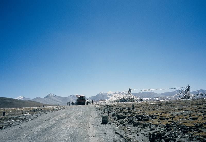 0
0 -
If coming over in Jan', just bear in mind that Chinese New Year kicks in around Jan 22nd, so flights will be more expensive after that - if you can actually find one.It's an uphill climb to the bottom0
-
Amazing pic! Yes, it brings me back - I remember when I was at exactly that point (although the road was empty at the time) I was too exhausted to be happy. In fact, by that time it was dawning on me that there was no great downhill, I'd be struggling for hours yet (it was after dark when i finally made it to the first village).
Thats an interesting idea, cycladalic, about buying a bike there. I do feel it a bit ironic to bring my US made Cannondale to the home of bike manufacture... Do you know of any good shops in Taipei where I can check availability and prices?0 -
I don't get into Taipei too often, even though it's only 50km north of where I live - it's a hassle. I just pop to my LBS, which is a Giant stockist. If I knew which model you might interested in I could check on the price for you.
I did do a comparison many years ago and I think it worked out about 25 per cent cheaper than UK prices. There must be websites for local stores - they may be in Mandarin. I will ask my wife to search for me.
If you are very tall the right frame size might take a while to get, as most Taiwanese are shorter than WesternersIt's an uphill climb to the bottom0 -
Thanks for the offer cycladelic, I will give it a bit of thought - most likely I will opt to bring my own (although a nice giant tcr is certainly tempting).0
-
-
I'm not sure if the Oregon can be mounted on a handlebar. It does look nice though.0
-
hi all, i've read numerous previous threads on the 705 and searched the internet for articles and have decided to take the plunge. I remember reading an article that recommended getting the city navigator maps on DVD rather than on SD but i cannot for the life of me remember why this was recommended. if anyone can give me the reason for this i would be greatful.
Also i was wondering when my garmin arrives what do i need to do to get it working well, re patches/downloads. Thanks.Your'e never alone with schizophrenia.0 -
GyatsoLa wrote:I'm not sure if the Oregon can be mounted on a handlebar. It does look nice though.
There is a bike mount:
http://www.globalgizmos.co.uk/product_d ... medium=cpc
I've seen reviews criticising the Oregon for not being very readable in bright light. If that isn't such a problem, go for it. But it might be worth seeing if you can find a shop where you can see it in operation.0 -
andymiller wrote:
There is a bike mount:
http://www.globalgizmos.co.uk/product_d ... medium=cpc
I've seen reviews criticising the Oregon for not being very readable in bright light. If that isn't such a problem, go for it. But it might be worth seeing if you can find a shop where you can see it in operation.
That would be a dealkiller for me - I only cycle in the sunshine 0
0 -
LingfieldXC wrote:I remember reading an article that recommended getting the city navigator maps on DVD rather than on SD but i cannot for the life of me remember why this was recommended. if anyone can give me the reason for this i would be greatful.
If you get the maps on DVD, you can use them on your PC for route planning etc. You can also replace your SD card if it gets corrupted or lost.
If you get the maps on SD card, then there's no backup possible. That means that you would be less willing to try things like adding your own point of interest files in case you get it wrong. You may also find that there's less free space on the card than you might like for recording your rides on.
You also can't use the Garmin maps for planning your rides, or for maintaining a visual map of where you've been. Memory Map or online planners like google maps in one of its various incarnations can be used, but the drawback of doing this is that if you create follow road routes with relatively few waypoints, you'll never be certain that where you get navigated is where you intended. The result would likely be that you end up using tracks or routes with lots of waypoints which take longer to prepare.0 -
Has anybody used/seen the SatMap GPS Sport device and if so is it any good for use on the bike (it does come with a bike mount).0
-
ermintrude
Lots of people rate it, but bear in mind that:
- you can only use the mapping on the SatMap;
- SFAIK you can't backup the SC cards;
- SFAIK there's only mapping for the UK.
Nice piece of kit. If you could run Windows Mobile and Memory Map on it, I'd buy one like a shot but as it is, it has limitations - though you may decide you can live with them.
Compare the battery life and screen brightness with the Garmin devices before making a decision. Worth checking whether you can buy replacement batteries - not sure if it runs on AAs or lithium-ion (lithium-ion are fine but you need a charger).0 -
Thanks so much for that Andy0