Sat Nav

oldholborn
Posts: 114
I would like to bolt sat nav on my handlebars.
Is it possible to get software to display green lanes and bridleways?
What is the cost of suitable soft and hardware?
Is it possible to get software to display green lanes and bridleways?
What is the cost of suitable soft and hardware?
0
Comments
-
Is there really any point? As with most electronic devices it wouldn't be too chuffed when it came into contact with water and mud, it'd weigh down your bike, and you'd be taking your eyes off where you are going to look at it. On top of that, I can't say I've heard of satnav that shows trails and greenlanes. If you are really serious about it the best thing you can do is to get one of those nokia phones with built in gps ans see if you can somehow mount that on your bars.0
-
Hi I use a Garmin (think the model is called the Legend CX). I use the Garmin Topo mapping software which shows the majority of bridal ways. I also use memory map to plan my routes on computer first before uploading them onto the GPS.0
-
Certainly is, but then again it is not when compared to other GPS.
I tour withthis and it is superb, just follow the dots!
Then you download the record of you route, warts and all.
Wouldn't be without mine<b><i>He that buys land buys many stones.
He that buys flesh buys many bones.
He that buys eggs buys many shells,
But he that buys good beer buys nothing else.</b></i>
(Unattributed Trad.)0 -
So is it not loaded with any maps when you get them?
as i am looking at a sat nav as i am wanting to do long rides, sort of ones over 3 OS maps so it would be easier to use this.0 -
Depends what you want as a "map"!
It is preloaded with a route atlas and steet level mapping, but Ordnace Survey are a nightmare with Copyright - hence you buy maps on cards ayt whatever scale you require.
All of the UK at !:50,000 is about £200 and you can get smaller areass. My present map covers Hampshire, West Sussex, East Sussex, Kent, Surrey, Berkshire, Oxfordshire, Buckinghamshire, Hertfordshire, Essex, Greater London. and was £60.
All mapping GPS is the same, as are the maping software programs.
So in answer to your question - if you navigate at stret level or main roads then it is pre-loaded, if you navigate at OS level then it is additional.<b><i>He that buys land buys many stones.
He that buys flesh buys many bones.
He that buys eggs buys many shells,
But he that buys good beer buys nothing else.</b></i>
(Unattributed Trad.)0 -
alright thanks.
I shall have to have a look around but something like this would be great!0 -
I thoroughly recommend the use of a GPS for cycling. It will save you hours on the trail.
However if you don't explore and only use waymarked cycle trails stop reading this now and save yourself some money.
I use a Garmin etrex Legend Cx. I bought it in the states at about half the UK price for around £75 but it comes with the US basemap not the UK one so bear this in mind if you buy an import from ebay. (the base map is not very detailed)
The advantages of an Etrex : You can buy a handlebar mount for the etrex range. They are waterproof and durable. The colour display works much better in daylight than a PDA and the batteries last 25 hours.
It's best to plan your route using something like
memory map (£100 per region) or
TrackLogs (£146 - 80km centred map)
the above use OS mapping on a computer and then upload the route to the GPS unit.
Not all GPS units support mapping. To upload maps to the GPS unit you need to get the Garmin map source software: -
Garmin Metroguide Europe V8 for roads (£100) no unlocking and no automatic routing on the GPS (or does it ;-)
City Navigator Europe NT for roads (£150)
UK Topo for bridle paths (£150)
Don't buy these second hand, once "unlocked" to a GPS unit the software is useless and if the GPS unit fails you will have to buy another copy (a bit harsh).
It's worth getting a: -
Cx model because you can expand the memory by buying a bigger micro SD card and a
H model to get the high sensitivity SiRF III receiver so you don't loose signal in the forest.
I woud get the Legend HCx (£170) if I were buying again but there may be newer stuff that is better.
You will need to buy the handlebar mount (£13)
The cable to connect to a computer is a standard mini USB on the newer Garmin models but on the older ones it's an expensive serial lead (£20)
Total cost £500? if you buy software0 -
so something like the Garmin Edge 205 on chain reaction would be usless?0
-
Here's the differences
Edge 205 (£108.37 at amazon)
Display monochrome 128 x 160 pixels
Basemap: no
Ability to add maps: no
Accepts data cards: no
Lap history: 1000 laps
Waypoints/favorites/locations: 100
Routes: 50
Bike mount included
Etrex Legend HCx (£139.99 at http://www.ebuyer.com/product/134129 and cheaper elsewhere)
Display colour 176 x 220 pixels
Basemap: yes
Preloaded maps: no
Ability to add maps: yes
Built-in memory: no
Accepts data cards: microSD™ card (not included)
Waypoints/favorites/locations: 1000
Routes: 50
Track log: 10,000 points, 20 saved tracks
Bike mount available not included
The edge doesn't do mapping but you could plan your route using memory map before going and then follow the route so it isn't essential. It looks like the edge 205 only has 100 waypoints memory and most of my routes go over 100 points so I think that would put me off buying it.
I think the Edge series are more geared up for measuring performance like for roadies training for time trials.They work out calories burnt and stuff and measure laps so if you are training for competition it may be the thing for you.
The etrex series is more geared up for backwoods navigation but it has a trip computer so you can compare times and the tracklog records your speed and GPS altitude at every part of the route. It suits me fine for finding my way round places I have never been to before.0 -
hmm, what about the 605 or 705?
all im really concerned of is buying one then needing to fork out for software that i might be able to get thats preloaded.
thanks0 -
abductee how do you get on with the Garmin mount? I bought that mount but didn't make much of it for mountain biking so switched to a RAM mount instead.0
-
The Garmin mount has been fine for me and it has been down some teeth chattering descents but I know someone who has overtightened the mounting screw and his failed at the hinge. I always loop the lanyard around the handlebars just in case.0
-
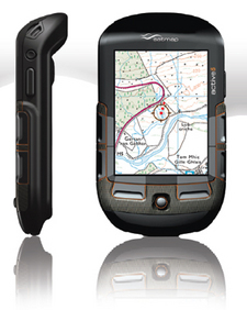
Th3 Firestarter wrote:I can't say I've heard of satnav that shows trails and greenlanes
I have the Satmap Active 10 and it shows all those features with full OS mapping, got my local area with 1:25000. It really is a superb bit of kit, and as regards GPS units its a total no brainer, its definitely going to be the yardstick for all future similar GPS's.
Check out The Gadget shows review of it, says it all.Vis Unita Fortior0 -
£4.50 os map £7.50 waterproof map cover. being able to read a map and not get lost priceless.
 a bike with round rubbery things
another bike with springy bits on it
another bike with too few gears0 -
Might be worth investigating ViewRanger... Not tried it but this is getting good reviews, + plus super helpful staff.
Basically makes your phone into a GPS with Os Maps.
(you need inbuilt gps, or bluetooth gps reciever.)
£15 for the software then you download the maps you want, at varying prices.
http://www.viewranger.com/0 -
Tel39 wrote:omaha wrote:£4.50 os map £7.50 waterproof map cover. being able to read a map and not get lost priceless.
The clue is in the title of the thread
sorry :oops: my point was, save your money, buy a map , learn a skill , take it with the money you've saved of to the Alps and have some outstanding MTBing
anyone can read gps, well till the battery runs down a bike with round rubbery things
another bike with springy bits on it
another bike with too few gears0 -
I found maps a bit difficult because I had to keep stopping to read them. Even with a map holder on my handlebars I would have to stop and check out where I was going because it is difficult to read whilst riding (especially off road). Also I would have to change the maps every so often when I cycled off the edge. With the GPS I can just glance at the screen and it tells me exactly where I am heading and when I next need to turn.0
-
fair point. i just think that ( unless it's inbuilt in your phone ) they're alot of money for a gadget . if im going XC far enough to warrant using a map or gps I'd have planed my trip so i could tell others , where , how far and when to expect me back, so I'd know which path's i should be on. ( more or less ) :? i still sometimes get lost tho
now if your to admit that it's really "look i've got another cool gadget that i can connect my ( fill in blank) ...... to " ! well then
p.s. I've got one in the work van :oops: a bike with round rubbery things
another bike with springy bits on it
another bike with too few gears0 -

My GPS is well worth the money, its not just some "cool" gadget to show off with. Most of the guys have already said the main advantages of them but the biggest thing for me is that i can keep riding and not have to stop to look at a map. Its also excellent when your out somewhere different and find a trail, just mark the position and then bingo you can easily find it on your next visit. Much easier than marking it on a map. Sure maps are fine for day trips but for long 60+ miles rides in one day you save so much time by having a gps to follow. I can read a map very well and always carry one when ever i do long rides or day trips but the GPS has so many advantages.0 -
If you get memory map you can upload OS maps to a mobile phone device. I have used a T-Mobile MDA Vario III and it works OK with memory map and it's great with Tom Tom in a car but I don't think its practical for use on a bike. The screen gets washed out by sunlight, it isn't waterproof, I don't think you could use it with gloves on, mounting it on the handlebars securely would be a challenge and the battery goes down really quick with the GPS turned on. Has anyone got real world experience of using a mobile phone for satnav on a bike? I know it's possible but how does it compare to a Garmin?
There are reviews of most of the devices mentioned in this tread here http://www.bikeradar.com/mtb/gear/category/accessories/gadgets/gps-devices0 -
Tel39 wrote:Th3 Firestarter wrote:I can't say I've heard of satnav that shows trails and greenlanes
I have the Satmap Active 10 and it shows all those features with full OS mapping, got my local area with 1:25000. It really is a superb bit of kit, and as regards GPS units its a total no brainer, its definitely going to be the yardstick for all future similar GPS's.
Check out The Gadget shows review of it, says it all.
Tel39 I have been looking at the Satmap is it easy to use while your wearing gloves I have a magellan and the buttons are impossible with gloves onFig rolls: proof that god loves cyclists and that she wants us to do another lap0 -
I have a garmin GPS 60, bought from Amazon, good price and their customer service is amazing.
For me this does everything I want, very tough, water proof and simple to use. Monochrome display which means that used in conjunction with some decent hi capacity re-chargeable batteries the battery life is enormous. The handle bar mount is good, it’s had a good bashing and the GPS has been thrown off the bars quite a few times when I’ve had a stack(always use the lanyard to tie it to the stem).
I use it along with memory map to plan my routes and so far has preformed great, easy plug and play. A GPS really is great when covering a lot of miles, most of my rides are 30-60miles. I used it when I rode the 100k at the HONC earlier this year and it was amazing, every turn shown, never had to check the map once (the route was not way marked) which meant more time riding. You can name waypoints if you wish to give you a bit more info i.e. keep left etc. and set alarms to attract you attention when approaching certain spots.
It has lots of functions similar to a cycle computer and you can customise the various displays to suit. When your done you can download the info after the ride into memory map or Google earth etc.
Overall a good bit of kit.[url]uttp://farm3.static.flickr.com/2453/3644058624_66a72402ee.jpg/]Hardtail[/url]0 -
A vote for the SatMap Active10. It has excellent routing and trail capability and the OS maps (if you get 1:25k) are fantastic for finding new trails. I love mine.
Flickr 0
0

