TransAmerica Trail


Comments
-
I did Yorktown to San Francisco (as far as Pueblo CO on your route) in 2001. Easier than cycling in Britain/Europe but crossing Kansas is tedious in the extreme. Start with Adventure Cycling (www.adv-cycling.com) - you'll be using their maps.
If you've specific questions I'll do my best to answer them.0 -
Start on the west coast so the wind will generally be at your back.
Dennis Noward0 -
chasctc - which month of the year did you start? I thought about leaving Washington DC in late April / early May, but I'm still deciding on when is a good time. I don't mind the heat but would prefer to avoid heatwave temperatures (and other dangerous weather). Also, how long did it take you? I'm wondering if the 90 day Visa will be enough for me - don't want it to turn into a race!
dennisn - I'm still in two minds which side I should set off from, for now Washington DC looks like a good place... simply because it'll mean that I've got the Rockie Mountains to look forward to whilst I'm cycling across Kansas!
As someone who has never visited the USA, it's good to hear that it'll be easier than cycling in the UK. The gps data from the Adventure Cycling Association website is helpful too. It looks like there are plenty of camping grounds and motels to stay at along the way.
All I need to do is sort out my visa, get the ticket for the flight over there, figure out what to take (I'll probably follow my usual tour list) and get a few miles in me legs.0 -
I flew to Newport News via Philadelphia in late April when VA temperatures were 85 with high humidity(get used to it!). I dont think I'd want to start much later due to heat in Utah/Nevada though it may be cooler on your northern route.
That's too early for W to E; I didnt meet anyone unless I had crossed the Mississippi. I took 56 days and could have taken less; reasonably fit I started too slowly having no idea how hard/easy it would be. But it's important to have some fitness as you'll hit big hills within a week whichever direction you travel in. Add at least a week for your route.
You'll have to put up with the weather - in Utah I had both 100 degrees and 3+ inches of snow (not on the same day but it was June!) and Nevada was even hotter. Across the Plains I was hit most days by windy conditions followed by torrential rain (usually 30 minutes worth). Usually you can take cover well before it happens as the clouds build up during the day. But you soon dry out! and you may have better luck.
Finally I was never bitten but being chased several times a day by packs of dogs rapidly loses its fun value - you have been warned.0 -
I reckon that with an average of 100Km a day, it'll take me 70 days maximum, the worse part looks like the flight over there and the flight back home.
Sound's like it'll be a real adventure. Can't wait to get started!0 -
I did this trip starting from Washington D. C. at the beginning of April 2004. Cycled down to Yorktown, which is the official start point of the Centenary Trail, then on to Florence Oregon and then down the coast to San Francisco to get the flight back home.
I was towing a bike trailer and had my 65th birthday on the way while crossing through Kansas. I managed to average 11 mph overall, longest day's ride 108 miles.
Glad I started early because I read stories of people who started later they had extremely hot humid and wet weather.
As far as wind is concerned I didn't think there was any prevailing wind, I got my fair share of headwinds and tailwinds.
Tip, make a very early start to miss most of the wind which starts blowing hard from about 10 a.m..
Found the American people extremely kind, helpful and welcoming.
I joined the http://www.warmshowers.org/welcome cycling hospitality list, stayed with various families who were very nice.
The people I stayed with in D. C. even picked me up from the airport, put me up for a couple of days, showed me all the sites around Washington.
I particularly enjoyed the Space and Aeronautical Museum.
I would recommend getting this book from Amazon £3.93. Bicycling Coast to Coast: Complete Route Guide Virginia to Oregon (Paperback)
by Donna Aitkenhead. It'll save you buying Adventure Cycling maps. It's what I used. It's exactly the same route as their maps but much cheaper. Gives you all the details of each days ride and where to stay.
If you do a Google search for the American tourist offices of the states that you will be passing through and contact them, they will send you, for free, their states roadmap.
Plenty of stories like this one on the web to read for information http://www.iowni.com/content/tour2002/
Two things I bought in Washington before starting out, which I found indispensable, were HALT! Dog repellent spray, you are going need it, them dogs are out to get cyclists and from Radio Shack, a small FM/Weather Warning radio. In the States they broadcast, continuously, the local daily weather forecasts and also give warning of any dangerous weather.
Saved my bacon a couple of times when I had to seek shelter, once from a tornado and once from very strong 90 mph wind.
I didn't stick slavishly to their route as they take you up and down every hill they can find. I often deviated to miss the hills by taking some main roads, particularly the main roads which have been replaced by a free-way. They were excellent and pretty free of traffic.
I was camping most of the time and when there wasn't a campsite nearby I found that if you asked nicely, people were very kind and didn't mind me camping in their garden. Note: Don't say garden say Yard when asking. Garden in America means where they grow their flowers and vegetables.
Found that a 2 inch thick self inflating mattress and a down sleeping bag to be great investments. Having warm comfortable nights sleep on such a long trip is mandatory.
Take warm and cool clothing with you. Temperatures varied a lot. 6 inches of snow in the Rockies to 98° lower down.
Going through Yellowstone Park try and make friends with somebody in a car to show you around. The park is a huge and the places of interest are far apart. I was very lucky and made friends with a photographer and he took me everywhere. Just another example of American hospitality.
Just a little extract from my diary. Scott City, Kansas, Sunday, May 30, 2004.
I am sitting in a restaurant having breakfast, fellow diners are dressed in jeans, cowboy boots, and Stetson hats. The wild West!! Breakfast menu, eggs, hash browns, Polish sausage, toast and all the coffee one can drink, $3.25.0 -
Excellent, thanks for the info cirrus18, I wasn't too worried by the dogs, but now you got me thinking... and as for the thought of confronting tornadoes, well I'm a bit nervous at the possibility!
I'll check that book out on amazon, the official maps are a bit pricey.
Do you think it's worth cycling down to the official start/finish in Yorktown? if it's like John O'Groats or Land's End (by being nondescript one horse towns) then I'd rather follow the Atlantic Coast Route to Richmond, and connect with the TransAmerican Trail from there (so I'll have an extra couple of days to spend elsewhere).0 -
Hi Dom,
I'm thinking of doing this route East - West (as part of a world trip) starting in May 08.
As Cirrus18 said, I'd start with getting Bicycling Coast to Coast: Complete Route Guide Virginia to Oregon (Paperback) as it's packed with info.
I'm based in West London and would be happy to meet up and share ideas. It's going to be my first cycle tour...
Aidan0 -
DomT wrote:Do you think it's worth cycling down to the official start/finish in Yorktown? .
I did the Lands End to John O'Groats ride in July 2003 and for me the only reason to go to the actual start/finish line is was to get my photograph taken at the famous signposts. Similar reason in America.
It doesn't matter if you miss out Yorktown (which is a largish town), you will have still ridden American coast-to-coast.
Don't let the stories of dogs/tornadoes worrying you too much. I only used the spray twice to discourage persistent dogs. Boy does it work! One squirt and they were off, tail between their legs. Normally, shouting at the top of my lungs SSSSit!! with emphasis on the sss hissing sound was enough.
I made a little holster, mounted on the handlebars, so that I could grab the spray quickly.
Similarly, tornadoes are few and far between and more than likely one has more chance of being struck by lightning here in the UK (which hasn't put you off cycling in the UK has it?) than meeting a tornado in the USA.
The Tornado I was talking about eventually passed some 20 miles to the south.
One thing which did cause me a bit of a hassle. I flew Virgin Atlantic and the only requirement out of the UK was to turn the handlebars and pedals around and deflate the tires. All very easy, no packing required.
At San Francisco airport they seemingly have a ruling (not Virgin Atlantic) that bikes must be packed in a box. Of course at this late hour I had no chance of getting a box, the flight was leaving in a couple of hours, eventually, they said it would be okay if I got the bike shrink wrapped. There was a guy at the airport wrapping up suitcases etc. He wrapped my bike for $15. Might be worth buying some bubble wrap before getting to the airport.ampr1150gs wrote:. It's going to be my first cycle tour...
Aidan
I think you would be well advised that before you start on such a world-tour adventure you should do some 500 mile plus tours here and in Europe first.
After all, you want to find out if you like and are capable of long distance touring first.
Doing it is harder than yakking about it in a pub you know.0 -
crazyguyonabike.com http://www.crazyguyonabike.com/ will give you loads of route dscriptions and there must be literally 100s of trans-USA tours on this site and loads of evocative photos.
Recommended for the armchair fantasist and wannabe tourist0 -
Ha, ha!... don't worry I won't let the dogs put me off, and as for the tornadoes, well, I wouldn't mind seeing one... but defiantly not close up!
I had wondered about the requirements for flying with a bike. I was going to purchase a lightweight bike bag and protect the tubes with piping insulation, but the thought of carrying a bag across USA only to be used twice seems a bit crazy. I'll figure something out.
Aidan, my first tour was 3400miles around Europe, so it is possible to do a long tour as your first (all I did was to read up on the subject and go for a few test runs before hand!) When I get hold of a copy of that book, I'll PM you. It'll be good to meet up and discuss ideas.
Keith, crazyguyonabike is a great site... I could spend hours on there!0 -
Did this in 2005...Heard the northern route is much more scenic...If you do TA..you can take a short cut and go from Missoula..and take the Lewis and Clark route to Astoria...cuts off 300 miles...and a lot of mountain passes..If you start on the west coast early some mountain passes are snowed in..I did e to w...You will find wind evens itself out..Virginia and Kentucky are very humid in the summer..Miss those if you go e to w..And be warned the Missouri is the hardest state to cycle thru..,,.for hills...
My advice ..miss out Colorado....go north from Kansas towards Wyoming...Colorado is very busy with traffic...And also miss out Yellowstone park....dangerous...Go into Jackson Hole and you can find a way thru to Montana..
My advice..make up your own route!..0 -
They're fascinating to watch, then, suddenly, very scary! I took this shot...DomT wrote:Ha, ha!... don't worry I won't let the dogs put me off, and as for the tornadoes, well, I wouldn't mind seeing one... but defiantly not close up!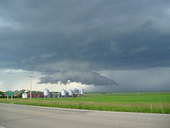
...5 mins before it touched down about a mile from us and headed off towards our campsite for the night. The high winds were OK, but the driving rain was painful, with huge, and I mean huge, bolts of lightning flashing all around. We got lucky and a farmer spotted us, huddling in a ditch at the side of the road, and invited us into his barn to shelter (bottom left of pic).
It'd be worthwhile finding out what to do should you encounter one.
Sounds like a great trip you're organising. I hope you're going to keep us posted about you're adventures.A fanatic is one who can’t change his mind and won’t change the subject - Churchill0 -
V4281051, spoke to a friend recently who also thought the Northern Tier route would be more scenic than the old TA route. I'm still in two minds whether or not to stick with the TA, but it looks most likely that I will.
As for Yellowstone Park and the busy bits, I think I'll worry about those things when I reach them - probably buy a detailed map and make a few detours using local knowledge, maybe even do a few off-road miles.
Crapaud, I definitely need to do some homework on twisters. I'm a bit clueless at the moment on the subject, but I'm sure a few google searches and a trip to the library will get me up to speed.
I'm not really a blogging kind of a person, but I'll try to keep one for this trip... will let y'all know closer to time!0 -
This is the route I would recommend. Much more scenic than the entire TA route.
Take TA route to Missouri and pick up the Lewis & Clark Route and then switch to the Northern Tier route to finish in Anacortes. (Actually, finish in Seattle a short shuttle from the airport by cycling just south of Anacortes to take the ferry from Whidbey Island to Port Townsend, cycle to Windslow on Bainbridge Island and take the ferry into downtown Seattle.)
This option, in my opinion, is a much more scenic route than the entire TA route.
Another option from Anacortes is to take the verry to Vancouver Island, then cycle north of the city of Victoria and take the ferry to Tsawassan in British Columbia and cycle to the Vanoucover Airport.0 -
It's funny you mention that, I was just figuring out where I should end the journey. Seattle caught my eye but I wouldn't mind cycling over the boarder and adding Canada to my "where I've been on my bike" list!
Thanks Spinnerman, I'll make good use of the ferry info. What is Seattle like? I hear it is similar to Scotland (weather-wise), but really have no idea... more googling I guess!
So far, my route looks something like this:
(As you see, it is still a bit vague!)0 -
looks pretty good. The only change I would recommend (because I have driven acorss those areas many times) is to either follow the Missori river north from the western end of Missori and then east across South Dakota rather than Kansas because it is much more scenic. Kansas is very flat and a long gradual altitude gain from about Topeka west. Missori or Iowa and then South Dakota has rolling hills with gradual alititude change.
Seattle is beautiful. Actually, access to the Seattle airport (Sea-Tac) is much easier from Downtown Seattle than Vanouver Airport will be from Tsawassan. If you ferry to Tsawassan, I would spend a little money and just take a Taxi from the ferry to a hotel near the airport. I would base your decisoin on which will offer a less expensive flight.
Both Vancouver and Seattle are beautiful cities surrounded by Mountains and water. Seattle is much warmer (usually) than Scotland in the Summer. Think Paris with low humidity (same latitude). Vaounver averages about 3 to 5 Celcius cooler than Seattle for a high temperature. The ferry ride from Bainbridge Islaand to Downtonwn Seattle is mangificent. here are some links http://images.search.yahoo.com/search/i ... h=108&vm=r and http://images.search.yahoo.com/search/i ... h=106&vm=r and http://www.hqphotography.com/Detailed/931.html
One option I highly recommend is to complete your ride to Seattle. Spend a day or two in Seattle getting your bike packed (you could visit this shop for help if you need to near pike place market http://www.elliottbaybicycles.com/ ) then take the Amtrack train from Seattle to Downtown Vanouver and spend a day or two visiting this beautiful city and then catch your flight home.
I live in a southern suburb of Seattle near Tacoma, WA. If you have any other questions. Feel free to let me know.0 -
I'd prefer to take a scenic route, but don't want to loose touch with humanity, so you would recommend avoiding Kansas (it doesn't look that inspiring on the map either!) and heading for South Dakota instead.
Would I be missing much by cutting out the TA section that goes through Colorado and Wyoming? V4281051 seems to think not!
Maybe I should use the TA to St Louis connect to the Lewis & Clark and follow that till it joins the Northern Tier and stay with that till Seattle, something like this: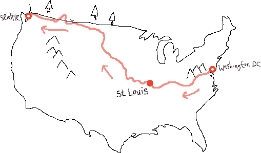 0
0 -
TA to Lewis and Clark to Northern Tier is probably the ideal route. Although you can modify it slightly as you go. Key Point os Intersest along the way are ...
1. Badlands of South Dakota.
2. Devils Tower Wyoming.
3. Grand Tetons Wyoming.
4. Yellowstone NP Wyoming & Montana.
If you can detour a little and take in Glacier NP by riding NE from Missoula I would defintely add this to your plans. Flathead Lake is also beautiful.
I think those are the highlights. The only thing you will really be missing is when the Rockies finally come into view as this giganitc wall of mountains coming out of the plains of Eastern Colorado. Other than that, I think missing out on crossing Kansas is a much better option. Also, the weather is a little less severe in South Dakota. Yes it is less populated, but you will just have to plan for it. By the time you get to the northern plains you will be a well seasoned touring rider in the US and will be able to handle it. Read other diaries from Crazy Guy on a bike to see what others have done when crossing less populated areas in the US. Basically just keep plenty of food and water on hand and be flexible with your itenerary in case you are riding into a strong headwind. You will have at least a couple of those days where it seems like an eternity to just get in 50 miles.
Have fun. Sounds like a great route..0