Garmin Edge 800 maps not recognised
dombo6
Posts: 582
I have an edge 800. Basemap and UK map from talkytoaster work fine but when I try to load OSM maps for any other country they go into the Garmin folder in the SD card but are not then recognised by the device. I am following instructions as per dcrainmaker, scarletfire etc but cannot get it to recognise them. Any advice as to what to do much appreciated.
0
Comments
-
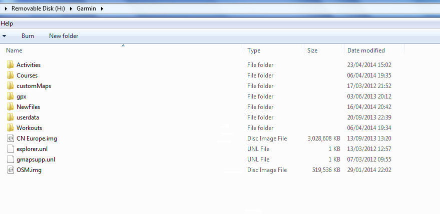
This is what my garmin folder looks like. Compare to yours.I have open streetmap osm.img and city navigator
cn europe.img 0
0 -
Thanks. Mine looks like that when I plug into the Mac, i.e. all the .img map files are showing in the Garmin folder in the SD card. However when I switch the device on and go to maps, only the basemap and original talky toaster UK OSM are available to use.
Very frustrating0 -
I know the answer to your problem and how to fix it.
Irregardless of the open street map file name your garmin gets the map name from the file header and not the file name.
Therefore if you have downloaded OSM for andorra and called it andorra.img, your garmin will still see it as something openstreetmap and will ignore the file name.
It is possible to split and rename the map tiles and then rejoin with a new file header. Instructions here.
http://forums.groundspeak.com/GC/index.php?showtopic=272486&st=0&p=4686955&#entry4686955
You need gmaptool and cgpsmapper installed. It is not a trivial task.
Or easier, just enable all osm maps on the device.0 -
Save your sanity and throw the Garmin away, heap of useless cack in my experience, utterly useless.Getting older and wanting to go further
Strava: http://www.strava.com/athletes/4664961
Twitter: @miles5050500 -
The Open Street Maps (OSM) are much better than the City Navigator ones. They include all the national cycleways and quite a lot of other paths, not all surfaced. If you want to use the unsurfaced ones just set avoidance to No (see screenshots in main article).
Open http://garmin.openstreetmap.nl/
Click Routable Bicycle.
Choose a predefined country (or create your own selection). For the UK click the Europe drop down and select United Kingdom from the list.
Download the map directly (if you selected a predefined country) or request your map by entering your email address and clicking Build my map (if you created your own selection); You will be sent an email after the map has been built by the servers.
You now have links to several options for your map. You need to select the one ending in gmapsupp.zip and download/save it to your computer.
Unzip this to get the file gmapsupp.IMG. You can rename this file to UKMap.IMG or anything else you will recognise. You can now delete the gmapsupp.zip file if you wish.
Put a blank microSD card into the 800. I use a 4GB one which has plenty of room.
Connect the 800 to the computer. It should auto open both the 800 and the card. Select Open folder to view files on the card.
Create a new folder on the empty card called Garmin.
Copy and paste the .IMG map file into the Garmin folder.
Safely remove the 800 from the computer and switch on. It will create other files in the Garmin folder and add the map to the 800. You should see it at the loading maps stage.
Go to Menu (spanner) >system > map > map info, select map. Enable the new map. Only enable the base map and the map you want to use. Disable all others.
If you want more maps the process is the same except you will need to rename the gmappsupp.IMG file to something unique before copying it into the Garmin folder.
This is my post on http://www.forgot.co.uk/edge-800/ There is a lot of useful info on there.0 -
Thanks for very detailed reply. However I did all that exactly as described but when I put the card back into the Garmin and switch it on, only the Basemap and the UK OSM map i downloaded from talky toaster are showing, not the latest one, even though it shows in the Garmin folder on the SD card when card is plugged into the Macbook.
Very frustrating to say the least.0 -
Dombo6 wrote:Thanks for very detailed reply. However I did all that exactly as described but when I put the card back into the Garmin and switch it on, only the Basemap and the UK OSM map i downloaded from talky toaster are showing, not the latest one, even though it shows in the Garmin folder on the SD card when card is plugged into the Macbook.
Very frustrating to say the least.
How do you know it is the uk osm map in the garmin map menu?
What country are you trying to load as I have renamed a few file headers for OSM for various countries.0 -
John.T wrote:Check the OSM maps have not been combined. I have UK and France on mine but they show up as one map. Look for somewhere on the new map. If it finds it then this is what happened.
^ +1 ^0 -
Thanks everyone. Finally sussed it - SD card was either faulty or too big at 32GB. Swapped it out for a 8GB one and all the OSM maps loaded fine, France, Italy, Spain, Switzerland, and good old UK from talkytoaster.0

